Special Offers

Leica RTC360 3D Laser Scanner (New) - Sale! (RTC360)
The solution for professionals to manage project complexities with accurate and reliable 3D representations and discover the possibilities of any site
$5,912.77 $7,210.70
The Leica RTC360 3D reality capture solution empowers users to document and capture their environments in 3D, improving efficiency and productivity in the field and in the office through fast, simple-to-use, accurate, and portable hardware and software. The RTC360 3D laser scanner is the solution for professionals to manage project complexities with accurate and reliable 3D representations and discover the possibilities of any site.
Highly portable, highly automated, intuitive and designed for maximum productivity, the RTC360 solution efficiently combines the RTC360 a high-performance 3D laser scanner, Leica Cyclone FIELD 360 mobile-device app for edge computing for automatically registering scans in real time, and Leica Cyclone REGISTER 360 PLUS office software to integrate your 3D model seamlessly into your workflow.
Capture scans, including enriching High-Dynamic Range (HDR) imagery, in less than two minutes.
Automatically record your moves from station to station to pre-register your scans in the field without manual intervention.
Augment your data capture with information tags illustrating the opportunities for better planning, reflect site reality, and boost your teams’ situational awareness
Directly publish your captured data from Cyclone FIELD 360 to Leica TruView Cloud to quickly exchange project information prior to import and registration
Fast
The new Leica RTC360 laser scanner makes 3D reality capture faster than ever before. With a measuring rate of up to 2 million points per second and advanced HDR imaging system, the creation of coloured 3D point clouds can be completed in under two minutes. Plus, automated targetless field registration (based on VIS technology) and the seamless, automated transfer of data from site to office reduce time spent in the field and further maximise productivity.
Agile
Small and lightweight, the Leica RTC360 scanner’s portable design and collapsible tripod mean it’s compact enough to fit into most backpacks, ready to be taken anywhere. Once on-site, easy-to-use, one-button operation makes for fast, hassle-free scanning.
Precise
Low noise data allows for better images, resulting in crisp, high-quality scans that are rich in detail and ready for use in a range of applications. Combined with Cyclone FIELD 360 software for automated registration in the field, the Leica RTC360 scanner offers outstanding precision that can be checked on-site.
Pre-registraton in the field
As part of the RTC360 solution, the Cyclone FIELD 360 app links the 3D data acquisition in the field with the laser scanner and data registration in the office with Cyclone REGISTER 360 PLUS. On-site the user can automatically capture, register and examine scan and image data. The user interface combines easy handling of complex calculations with a graphical user guidance that offers a remarkable user experience, also for novice users.

Artec Leo 3D Laser Scanner (New) - Sale! (Leo 3D)
The world’s first wireless and AI-driven 3D scanner
$5,870.50 $7,159.15
Easy 3D scanning: see your object projected in 3D directly on the HD display!
The first 3D scanner to offer onboard automatic processing, Artec Leo is able to provide the most intuitive workflow, making 3D scanning as easy as taking a video. As you scan your object, see the 3D replica being built in real time on Leo’s touch panel screen. Rotate the 3D model, check if you have captured all areas, and fill in any parts you may have missed.
NEW AI-Powered HD Mode:
High resolution: Powered by Artec 3D’s AI neural engine, you’ll get stunning, sharp 3D scans with a resolution of up to 0.2 mm thanks to the new HD Mode for Artec Eva and Artec Leo scanners.
Capture smaller, thinner elements with your 3D scanner in HD, and with minimal noise.
Artec Leo 3D Scanner Features:
The most mobile 3D scanner on the market
Built-in touch panel screen and simple interface
Built-in 9 DoF inertial system
Unparalleled texture to geometry mapping
Large, professional grade lens system
Enhanced color capture
No need for targets
Comes with a 2-year warranty
3D scan and process even large objects quicker than ever before
Artec Leo Applications: With the ability to 3D scan and process large objects quicker than ever before yet also capture even small details, the Artec Leo is a perfect solution for industrial design, manufacturing, healthcare, science, education and art/design.

Leica ScanStation P30 3D Laser Scanner (New) - Sale! (ScanStation P30)
Your perfect partner when capturing 3D geometry of civil infrastructure
$5,875.12 $6,911.91
The Leica RTC360 3D reality capture solution empowers users to document and capture their environments in 3D, improving efficiency and productivity in the field and in the office through fast, simple-to-use, accurate, and portable hardware and software. The RTC360 3D laser scanner is the solution for professionals to manage project complexities with accurate and reliable 3D representations and discover the possibilities of any site.
Highly portable, highly automated, intuitive and designed for maximum productivity, the RTC360 solution efficiently combines the RTC360 a high-performance 3D laser scanner, Leica Cyclone FIELD 360 mobile-device app for edge computing for automatically registering scans in real time, and Leica Cyclone REGISTER 360 PLUS office software to integrate your 3D model seamlessly into your workflow.
Capture scans, including enriching High-Dynamic Range (HDR) imagery, in less than two minutes.
Automatically record your moves from station to station to pre-register your scans in the field without manual intervention.
Augment your data capture with information tags illustrating the opportunities for better planning, reflect site reality, and boost your teams’ situational awareness
Directly publish your captured data from Cyclone FIELD 360 to Leica TruView Cloud to quickly exchange project information prior to import and registration
Fast
The new Leica RTC360 laser scanner makes 3D reality capture faster than ever before. With a measuring rate of up to 2 million points per second and advanced HDR imaging system, the creation of coloured 3D point clouds can be completed in under two minutes. Plus, automated targetless field registration (based on VIS technology) and the seamless, automated transfer of data from site to office reduce time spent in the field and further maximise productivity.
Agile
Small and lightweight, the Leica RTC360 scanner’s portable design and collapsible tripod mean it’s compact enough to fit into most backpacks, ready to be taken anywhere. Once on-site, easy-to-use, one-button operation makes for fast, hassle-free scanning.
Precise
Low noise data allows for better images, resulting in crisp, high-quality scans that are rich in detail and ready for use in a range of applications. Combined with Cyclone FIELD 360 software for automated registration in the field, the Leica RTC360 scanner offers outstanding precision that can be checked on-site.
Pre-registraton in the field
As part of the RTC360 solution, the Cyclone FIELD 360 app links the 3D data acquisition in the field with the laser scanner and data registration in the office with Cyclone REGISTER 360 PLUS. On-site the user can automatically capture, register and examine scan and image data. The user interface combines easy handling of complex calculations with a graphical user guidance that offers a remarkable user experience, also for novice users.

GeoMax Zoom 50 Total Station (New) - Sale! (Zoom 50)
The highest performance on all levels even under the most challenging conditions
$4,341.35 $5,107.47
When you need the highest performance on all levels even under the most challenging conditions, the GeoMax Zoom50 series is the perfect choice for you.
With the proven accXess technology, the Zoom50 features an intelligent distance measurement engine designed for outstanding range, speed, and highest accuracy even under tough conditions.
The longer measurement range means a wider operational coverage and significantly less time lost with switching setups. The new "PowerLock“ protection mechanism prevents the use by unauthorized persons and makes it unattractive to steal.
All this in combination with the extra-wide color touchscreen, built-in Bluetooth®, USB memory stick support, and featured application package including even advanced functionalities makes the Zoom50 the true flagship of the Geomax manual total station family.
Colour and touch screen
• Large 3.5″ Q-VGA display
• Crystal clear experience
• Super fast navigation
Superior accXess10 EDM
• 1,000 m non-prism range
• Highest reliability & accuracy
• Pin size laser beam
Superior software
• Intuitive software
• Versatile, enhanced applications
• PowerLock theft protection
Features:
• “GeoMax Superior” powerful onboard SW
• “PowerLock” theft protection
• “SecureLock” Drives
• accXess EDM technology up to 1000m non-prism range.
• Quadruple Axis Compensation
• Coaxial visible laser beam
• Laser plummet
• High resolution, large Q-VGA color & touch display
• USB & RS232 Connection
• Built-in Bluetooth®
• USB memory stick
• 16 hours battery life
• Polar Option –30°C
Zoom50 accXess5: Long-range distance measurement on reflector and >500m non-prism*
Zoom50 accXess10: Ultra long-range distance measurement on reflector and > 1,000 m non-prism*
ANGLE MEASUREMENTS
Accuracy: 1” (0.3 mgon), 2” (0.6 mgon),5” (1.5 mgon)
Display resolution: 0.1” / 0.1 mgon
Method: Absolute, continuous,diametrical
Compensation: Quadruple axis
INTERFACE
Keyboard : Full alphanumeric, dual face (opt.)
Display : 3.5” Quarter-VGA color touch screen (320x240 pixel), 10 lines x 30 characters, self heating, illuminated
Data recording : Internal memory 50,000 pts
Interface : USB, serial & external power
Removable memory : USB memory stick
Bluetooth : Device Class1
DISTANCE MEASUREMENTS
Prism : 3,500 m / 2 mm 2 ppm
Long range : 10,000 m / 5 mm 2 ppm
Typ. meas. time : 1 s**
Non-prism : >500m accXess5 >1000m accXess10 2mm 2ppm***
Footprint : 8 x 20 mm****
POWER SUPPLY
Internal battery : Removable Li-Ion
Operating time****** : 36 h (continous angle), 16h (continous distance measurement every 30s)
PHYSICAL SPECIFICATIONS
Weight : 5.1 kg (incl. battery & tribrach)
Operating temp. : –30°C to 50°C*****
Protection class : IP55 dust and waterproof
Humidity : 95 %, non-condensing
PLUMMET
Type : Laser point, adjustable brightness
Accuracy : 1.5 mm at 1.5 m instrument height
OPERATING SYSTEM
Microsoft® : Windows embedded CE
* Optimal conditions to Kodak Grey Card (90% reflectivity)
** IR-Quick mode
*** >500m : 4 mm 2 ppm
**** At 50 m distance
***** Optional tested polar version, standard –20°C to 50°C
****** Battery time may be shorter depending on conditions.
All trademarks and trade names are those of their respective owners.
EN 60825-1; Laser plummet : Laser class 2 in accordance with IEC 60825-1 resp. EN 60825-1,
Distance meter (Non-Prism Mode accXess) : Laser class 3R in accordance with IEC 60825-1 resp. EN 60825-1
accXess (Select Range) : A5 (500m Reflectorless) A10 (1000m Reflectorless)
Accuracy (Select Accuracy) : 5" 2" 1"
Software : COGO; Ref. Arc; Road 3D, Traverse; PIN/PUK

Bruker EOS 500 Handheld LIBS Analyzer (New) - Sale! (EOS 500)
Handheld Laser Induced Breakdown Spectroscopy (HH-LIBS)
$4,882.63 $5,612.22
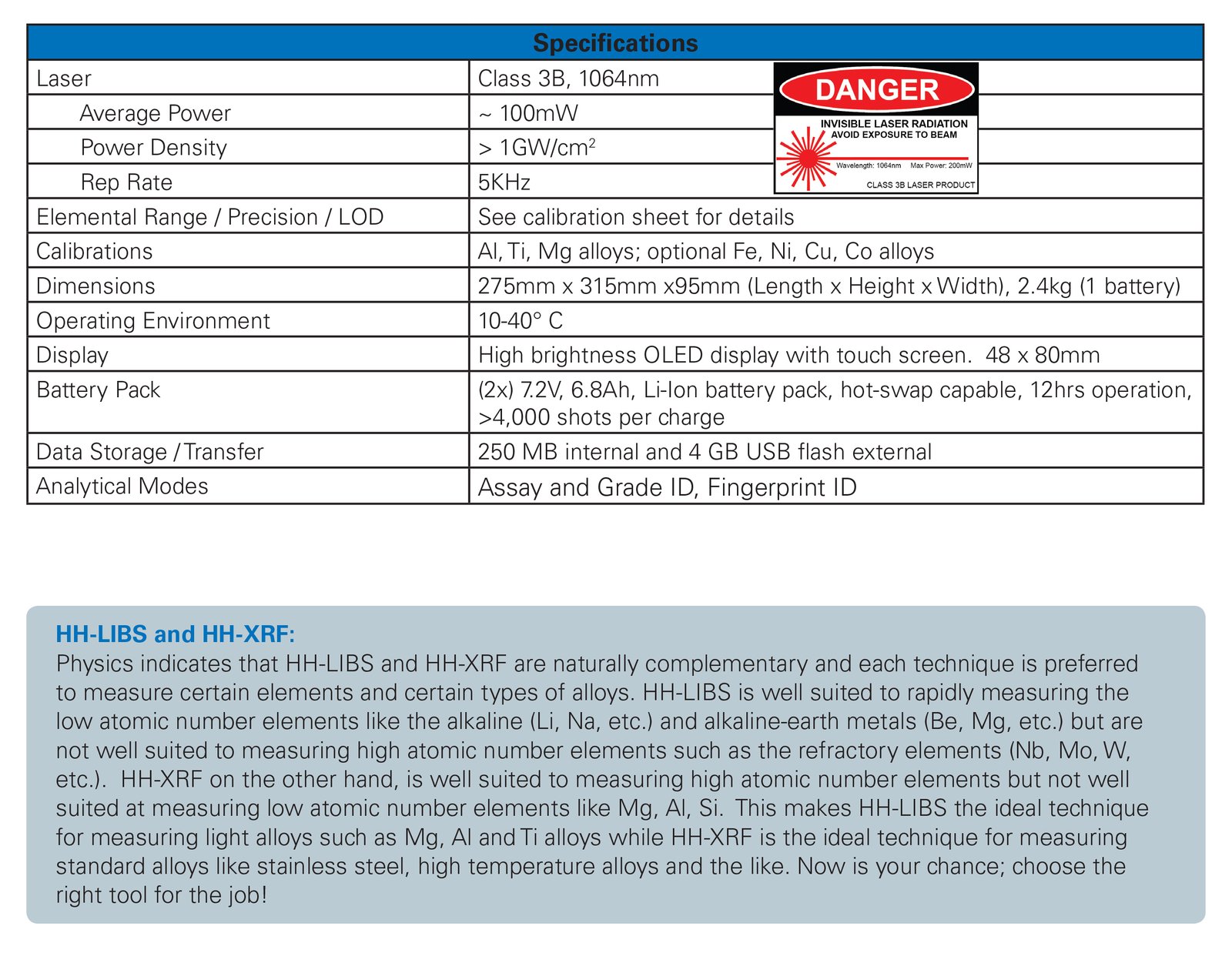
The Bruker EOS 500 Laser Induced Breakdown Spectroscopy (HH-LIBS) analyzer is designed to analyze the elemental composition of metals. The EOS 500 works by laser excitation of a sample followed by quantitative analysis of the plasma generated from the laser. In 3-5 seconds you will get a reading of the alloys included in the test sample including aluminum/titanium/magnesium alloys.
Fast, Lightweight & Analyzes Light Elements
EOS 500 is well suited for use in scrap sorting of alloys because of its lightweight (2.4 kg including battery), fast analysis and ease of operation. In addition to the standard XRF elements, the EOS 500 can analyze very light elements such as Li, Be and B, and is the preferred analyzer for measuring elements such as Mg, Al, Si. For light element analysis with the EOS 500, it is approximately 10x faster than XRF, easily saving you time and money. Optional calibrations are available for Iron, Nickel, Copper and Cobalt alloys.
Accurate & Repeatable
Bruker designed the EOS 500 for accurate and repeatable results. Bruker designed an Air-Flow Optics ShieldTM to ensure dust generated from laser ablation does not contaminate measurements.
Easy To Use
The EOS 500 is laboratory-grade hardware however is it easy-to-use. Its interface is intuitive, results presentation simple to read and data management and transfer are a snap. Operating the unit requires very little training. Report generation tools are included.
No X-Ray Regulations
Since the EOS 500 uses LIBS technology, there are no X-ray regulations concerning its use.
Extensive Grade Library & Effective Software
Bruker's EOS 500 includes extensive grade libraries (400 grade definitions) covering various international standards. User selectable libraries including UNS, DIN and others. With the Bruker Toolbox software you can modify existing alloy grade definitions, add new alloy grades and upload, download and share grade libraries across instruments.
OVERALL FEATURES
- Handheld LIBS Technology
- No X-ray Regulations
- Preferred for Li, Mg, Al, Si
- Fast Grade ID & Chemistry
- Accurate & Repeatable
- Flexible Battery Design - 1 battery operation for reduced weight or 2 battery operation for 12hr run-time
- EOS 500 has “Hot-swap” capability
APPLICATIONS
- Metal sorting and valuation
- Fingerprint ID
- Positive Material Identification (PMI)
- Light element capability
- Li, Be, Mg, Al, Si
EOS SOFTWARE FEATURES
- Intuitive icon-based software
- Multi-Level Users login account for fleet management & user identification
- On-board instrument performance check
- On-board averaging with burst mode
- Type standardization
- Assay & grade ID mode based on advanced chemometrics algorithm
- Fingerprint spectral ID mode
EXTENSIVE GRADE LIBRARY
- Modify existing Alloy Grade Definition
- Add new Alloy Grades
- Upload, download and share grade libraries among instruments
EASY TO USE
- Intuitive user interface - just point and shoot
- Requires very little operator training
- Multiple fields for sample identification
- Report generation tools
- Lightweight – only 2.4kg, including battery
WARRANTY
- Standard 1 Year Warranty

$5,208.17 $5,986.40
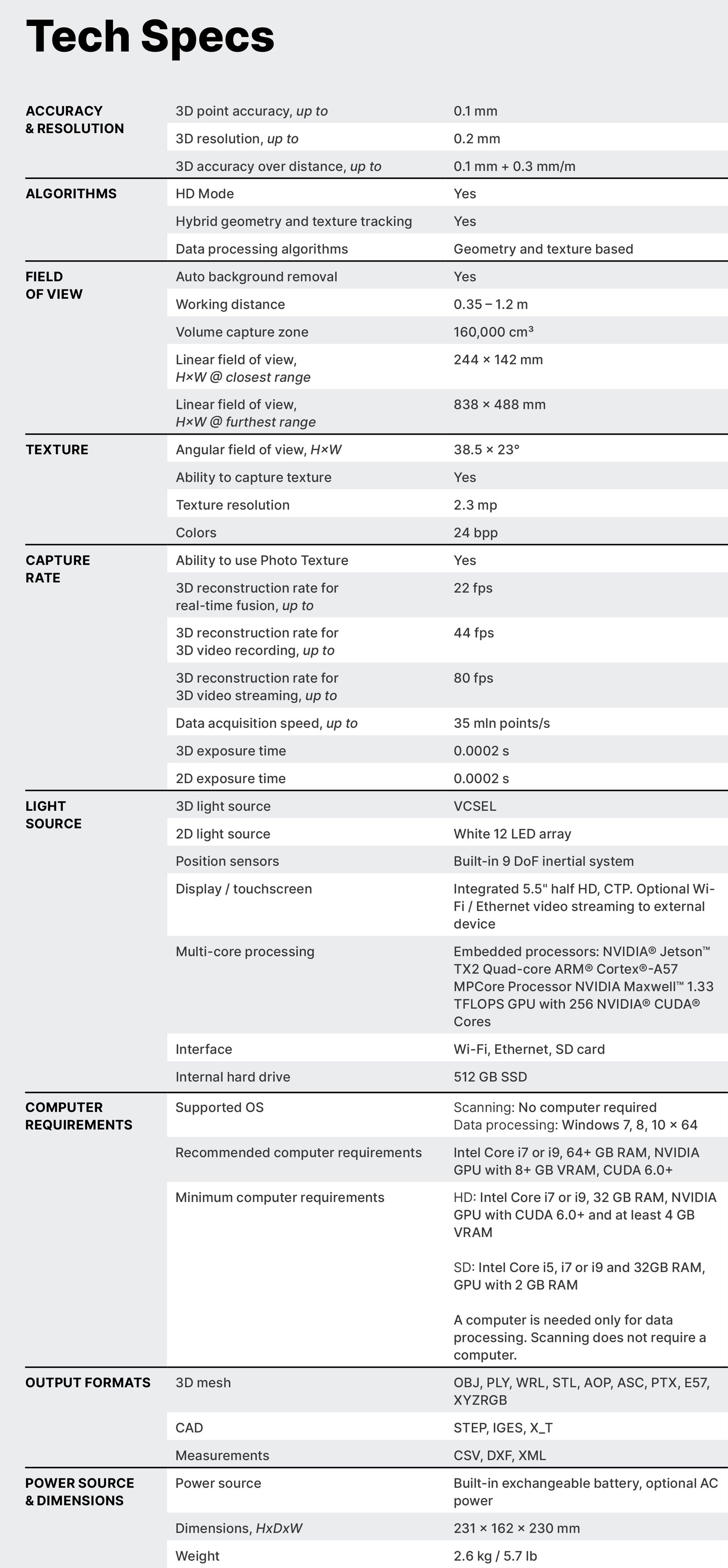
This Artec Leo 3D scanner is a handheld device that is perfect for color scanning. It is a great choice for those who are looking for a high-quality 3D scanner that is both portable and efficient. You don’t need a computer to be able to scan, it’s like a 3D camera that scans without tags, not like other 3D scanners.
Artec Leo is the only wireless and fully standalone professional 3D scanner designed to make scanning as easy and effortless as possible. With the new NVIDIA Jetson TX2 processor onboard, 5” HD built-in display and battery, it’s the ultimate all-in-one 3D scanning solution for fast, accurate, and high-quality data capture.
Interactive real-time scanning hints, hybrid target-free tracking system, smart scanning modes for faster data processing – just a few things that make our Leo the easiest 3D scanner to use. Just pick it up, point at whatever you want to scan, and hit that start button. Leo will take care of the rest.
Leo’s unique features: a compact design, long-lasting battery, interactive touch screen, scan-to-cloud, WiFi connectivity, and remote control combine to give you all the scanning and data transfer functionality you might require, right from the device itself without the need for additional devices, power or data cables.
Interactive 5.5" touch panel
With Leo’s intuitive UI, you can manage your device, scanning process, and scan data. The touch screen builds a real-time replica you can interact with while you scan, showing you areas that need attention, and helping you quickly get the best results.
The 2022 Artec Leo remains at a stable and optimal temperature throughout the scanning process to bring your accuracy to the next level, while a calibration certificate and Leo Calibration Kit guarantee top quality is maintained every step of the way.
Up to 0.1 mm point accuracy
The resolution of your scan data steps up 2x while removing noise for you, leaving you with the tidiest noise-free 3D model. Hard-to-reach areas and difficult-to-scan surfaces such as thin ridges or sharp corners are now easier than ever to capture, with enhanced reconstruction and improvements to edge curvatures. Forget about texture bias too – there’s no room for false geometry from high-contrast texture here. Expect true-to-life 3D models in stunningly high resolution.
Includes:
Artec Leo
Calibration kit
Additional battery (2 in total)
Battery charger
2-year warranty

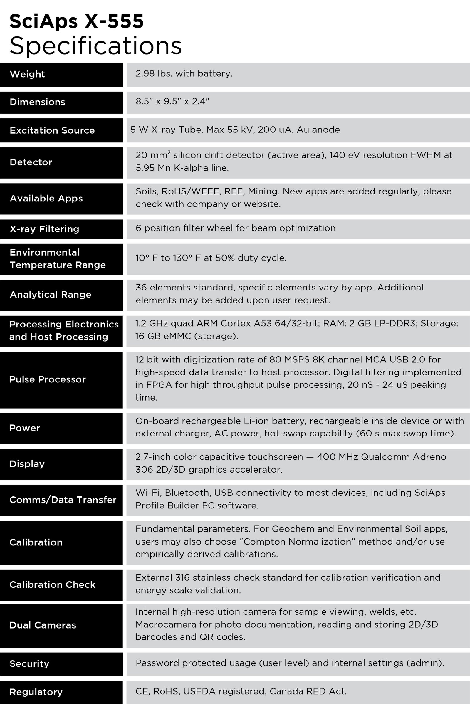
SciAps X-555 Handheld XRF Analyzer (New) - Sale! (X-555)
The lightest ever made, weighing in at just under 3 lbs. with battery
$4,555.41 $5,176.60
Premium performance begins with the most advanced handheld XRF technology available, led by a 55 kV X-ray tube for extra low detection limits on key elements like Ag, Cd, Sn, Sb, and Ba. Up to three automated beam settings provide optimal performance across the entire periodic table from Mg to U. All in a rugged instrument with state-of-the-art software and outstanding thermal dissipation.
IN USE GLOBALLY
Mining
Best-in-class light element performance for ultra low detection limits of elements like Mg, Al, Si, P, and S, while also packing enough power to achieve impressive precision on heavy elements like pathfinders Ag, Sn, Sb, and rare earth elements.
Soils
Appropriate filtering to optimize sensitivity — 2x better analysis of cadmium detection than any other XRF! Packs the industry’s most powerful X-ray tube for superior limits of detection—especially for cadmium, silver, tin, antimony and barium. When combined with the new Z-901 Beryllium, get 13 EPA Priority Pollutant Metals. Operators can upgrade the Z-901 Lithium to include lithium, boron, carbon, nitrogen, fluorine, and sodium in their tests, too.
Regulatory Markets
Next-generation connectivity, test data management and reporting for the full range of compliance testing applications, including RoHS, Halogen Free, CPSIA, and lead paint in children’s playgrounds. State-of-the-art data management incorporated into a flexible Android system allows for the greatest customization and data management capabilities.
Electric Vehicle and Strategic Metals
The 55 kV operation, rather than the industry typical 50 kV, delivers higher performance for critical “light” REEs and some “heavy” REEs, making it a superior option for REE analysis globally. Read more: SciAps for Electric Vehicle & Strategic Metals.
SciAps XRF analyzers are the lightest ever made, weighing in at just under 3 lbs. with battery. The durable aerospace-grade aluminum frame passes the Oops Test and the falling-from-a-35-foot-tower test. Redesigned housing with improved heat dissipation allows for high throughput testing that our customers demand. A narrow, slender form factor accesses the toughest test locations, with a 2.7″ display for rear viewing of grade and chemistry.

SciAps X-550 XRF Analyzer (New) - Sale! (X-550)
The most dynamic XRF in the market! HUD-accepted for lead-in-paint detection
$4,499.70 $5,113.30
The SciAps X-550 sets a new performance standard for handheld XRF. It is the lightest, fastest, most articulate X-ray gun ever made. It delivers the small size, blazing speed, and high precision of the SciAps X Series in a perfectly balanced device. It is fast on all alloys, including aluminum. It is HUD-accepted for residential and commercial lead-based paint analysis and documented in the Performance Characteristic Sheet (PCS). The X-550 uses the industry’s most powerful X-ray tube. The unique geometry and tube power optimize performance for low atomic number measurement applications including sulfidic corrosion (low Si), phosphorus and sulfur, and aluminum alloys, as well as for residuals analysis per API 751 and 5L specifications.
Features:
No radioactive isotopes: Greatly reduces the burden of owning and controlling radioactive materials and costly replacement.
Highest levels of accuracy: No substrate corrections, no inconclusive ranges or tests, even for action levels as low as 0.5 mg/cm2.
Fastest tests : Test in 2-6 seconds, and never lose speed over time. Quick Mode preferred for PCS types of testing, and Timed Mode for industrial lead paint testing. Delivers PMI for most alloys in 1-2 seconds with excellent precision.
The Cloud, Connectivity, and Android: Built on Google’s Android platform for real-time data exporting.
Applications:
HUD-accepted for residential and commercial lead-based paint analysis
Alloy analysis
Soil analysis
Mining and mineral analysis
Industrial lead analysis
Specifications:
Weight | 2.98 lbs. with battery |
Dimensions | 8.5” x 9.5” x 2.4” |
Power | On board rechargeable Li-ion battery, rechargeable inside device or with external charger, AC power, hot-swap capability (60s max swap time). |
Display | 2.7-inch color capacitive touchscreen — 400 MHz Qualcomm Adreno 306 2D/3D graphics accelerator. |
Comms/Data Transfer | Wifi, Bluetooth, USB connectivity to most devices, including SciAps ProfileBuilder PC software. |
Security | Password protected usage (user level) and internal settings (admin). |
Regulatory | CE, RoHS, USFDA registered, Canada RED Act. |
Excitation Source | 5 W X-ray tube. Typical: 40 kV, 200 uA Rh or Au anode. Anode choice depends on what other apps users may want to add. |
Detector | 20 mm2 silicon drift detector (active area), 140 eV resolution FWHM at 5.95 Mn K-alpha line. |
X-Ray Filtering | 5 position filter wheel for beam optimization. |
Processing Electronics and Host Processing | 1.2GHz quad ARM Cortex A53 64/32-bit, RAM: 2GB LP-DDR3, Storage: 16 GB eMMC (storage). |
Pulse Processor | 12 bit with digitization rate of 80 MSPS 8K channel MCA USB 2.0 for high-speed data transfer to host processor. Digital filtering implemented in FPGA for high throughput pulse processing 20 nS – 24 uS peaking time. |
Environmental Temp. Range | 10°F to 130°F at 25% duty cycle. |
Calibration | Linear or quadratic lead calibration with absorption and depth corrections. |
Calibration Check | External 316 stainless check standard for energy-scale calibration verification. NIST 1.04 mg/cm2 lead paint standard on wooden substrate block for PCS calibration check standard, with other lead levels available for alternative action levels. |
Analytical Range | 32 elements standard, specific elements vary by app. Additional elements may be added upon user request. |
Available Apps | Alloy, Geochem (Mining), Empirical, Environmental apps. Lead in paint app based on HUD-accepted PCS standard. |
Grade Library | Standard library contains 500 grades, no practical size limit. Multiple libraries supported, grades may be added on analyzer or via PC software package (ProfileBuilder). |

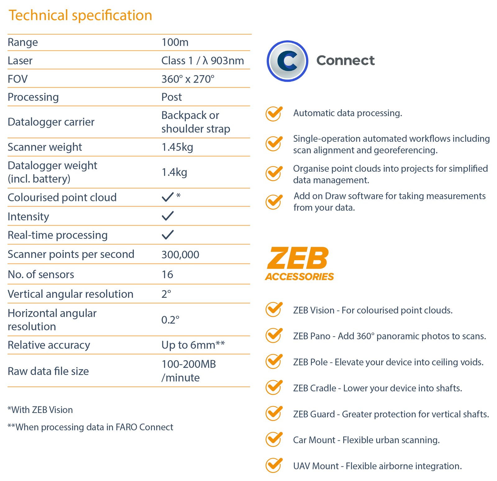
GeoSLAM ZEB Horizon RT Mobile Scanner (New) - Sale! (ZEB Horizon RT)
A mobile LiDAR scanner with high versatility
$5,029.86 $5,715.75
A mobile LiDAR scanner with high versatility, ZEB Horizon RT is the ideal solution for a variety of workflows including both outdoor and indoor mapping. Ideal for geospatial surveying including construction, mining or forestry, the compact design offers one tool for many solutions. The real-time feedback feature ensures users capture all the data they need while on-site, resulting in cost savings and faster job turnarounds.
Powered by GeoSLAM’s proprietary and ever-evolving SLAM algorithm, the ZEB Horizon RT is the ideal solution for surveying professionals looking for faster deliverables and higher efficiency, with the ability to scan handheld or via drone, car mount, cradle, pole, or backpack.
Business Value of GeoSLAM ZEB Horizon RT
Transition Through Environments
Seamlessly transition through an area, capturing entire datasets in one go. From interior to exterior, or stairwell to corridor, walking and mapping are made easier with mobile LiDAR solutions like the ZEB Horizon RT.
Map Hard to Reach Areas
Better understand spaces by capturing hard-to-reach sections of an area. The versatility of the ZEB Horizon RT provides opportunities to lower a scanner into vent shafts or elevate it into ceiling voids, increasing user safety.
Capture Data Faster
The lightweight nature of the scanner unlocks the potential for faster data capture. There isn’t a requirement for multiple setups to provide a desired outcome. Users simply need to switch on the scanner, walk and scan simultaneously, and return to their beginning point.
Repeat Scans as Often as Needed
The ease of use leads to anybody being able to map an area quickly with the mobile scanner. The process is repeatable as often as every day, if needed, leading to frequent and up-to-date data for all stakeholders, for more informed and faster decision-making.
It’s Not Just About Data Capture
Data capture is just one component of many workflows. What happens to that data and how information is extracted is equally, if not more, important. A solid software platform, like FARO Connect, provides the means to process data quickly and offers an array of automated pre-built workflows – such as change detection — allowing users to make the most of the data they collect.
Take Your Data Further
Following initial processing and analysis, point cloud data can be taken into a range of third-party software to make further enhancements and complement existing workflows.
Complement Other Forms of Data Capture
Combining SLAM systems with other LiDAR solutions, like the FARO Focus, offers a complete data capture package for an accurate, fast, and repeatable way to obtain point cloud data.
Features:
- 300,000 scan points per second
- 16 sensors
- Up to 6mm relative accuracy
- Up to 100-meter range
- Accessory options to enable users to capture data in a variety of ways

Leica ScanStation P50 3D Laser Scanner (Used) - Sale! (ScanStation P50)
Long Range 3D Terrestrial Laser Scanner
$4,974.90 $5,653.30
The ScanStation P50 is made for industry professionals, combines the functionality of the Leica ScanStation P40 with a dramatically longer scan range more than 1 kilometre to the well-known features of the P-series such as high speed, excellent data quality, HDR imaging, Check&Adjust, ease-of-use and ruggedness.
Unlike any other laser scanner, the Leica ScanStation P50 is the fastest and safest, long range 3D laser scanner, the solution is to maximises productivity by scanning inaccessible places at a safe position on site, reducing time in the field with less setups.
The ScanStation P50 is made for reality capture professionals who require extended range for their scanning jobs. This can be new users with a need for long range scanning, or existing users of a ScanStation P40/P30, who want to upgrade to the P50 in order to expand their business opportunities.
The ScanStation P50 can be used in all sorts of indoor and outdoor laser scanning projects where high data quality is a must, but with a focus on longer distances to be covered. This ranges from capturing tall buildings and large infrastructure objects such as skyscrapers, dams and bridges, to the 3D documentation of big pit mines. Unreachable sites like hillside slides can also be scanned from a remote and safe position.
The use of the ScanStation P50 is really easy. It comes with a user-friendly touch screen interface and can be controlled remotely by handheld devices. The ScanStation P50 is fully embedded in the Leica Geosystems High-Definition Surveying (HDS) workflow. Data can be processed in the Leica Geosystems 3D point cloud software suite. For example, data can be registered in the new Leica Cyclone REGISTER 360 and then further processed with Leica Cloudworx plug-ins for CAD platforms or web-based Leica TruView.
High performance under harsh conditions: The extremely durable new Leica ScanStation P50 performs even under the toughest environmental conditions, such as under extreme temperatures ranging from -20°C to 50°C and complies with the IP54 rating for dust and water resistance.
INCLUDED:
Leica ScanStation P50
GVP645, ScanStation transport container
GDF323 Tribrach PRO without optical plummet
4x GEB242, Large Li-Ion Battery 14.8V/5.8Ah (requires pro charger) for MS/TS/TM50 instruments
GKL311 Single Charger Prof 3000. Charger for one Li-Ion battery including AC/DC adaptor and cigarette lighter cable thumbnail
GEV228,ScanStation Pxx data cable, 2.5m, standard Ethernet Jack to Lemo (8 pin). Connects ScanStation Pxx with Computer
GHM008, Scanner height meter
GHT196, Distance holder for height meter.
Cyclone CD-ROM
1 Year P50 Basic support agreement
Additional Accessories:
B&W scan targets and target accessories
Range of Customer Care Products (CCP) that include support, hardware & software maintenance and extended warranty
External battery with charging station, AC power supply and power cable
Professional charger for internal batteries
AC power supply for scanner
Tripod, tripod star, rolling base
Adapter for upside down mounting

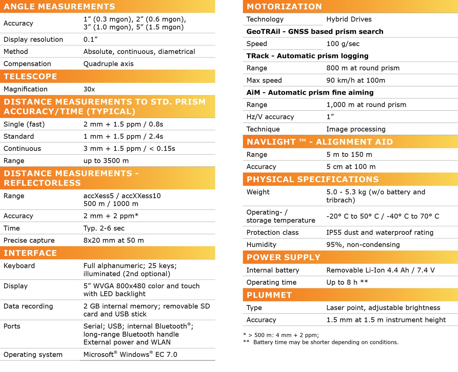
GeoMax Zoom 90 Robotic Total Station (New) - Sale! (Zoom 90)
The ultimate one-man system with up to 20% more automation performance
$4,992.99 $5,610.10
Features:
- Zoom90R, A5, 5" Package
- Dramatically minimize the time of any survey task and boost your performance and accuracy to the maximum.
- Zoom90 is the ultimate one-man system with up to 20% more automation performance, extended reflectorless measurement capability, STReAM360, accXess technologies and Windows CE open connectivity.
- Scout : Scans the entire working area within seconds to quickly find the target.
- TRack : Continuously track targets. Once locked onto, the instrument remains accurately aimed on the moving target.
- Aims accurately at any prism, without needing to look through the telescope.
- Measurements are performed automatically with consistently high and repeatable dependability.
- Zoom90 incorporates highly innovative X-motion hybrid drives, promoting automation performance compared to conventional drives.It will follow your target at 90 km/h at 100 m distance.PR
- GeoMax’s accXess EDM Technology provides leading reflectorless measurements up to 1000 m.
- The extra small laser footprint and the sophisticated signal-processing technology, ensure you accuracy - regardless of the distance or conditions.
- Fitted as standard in the telescope, the NavLight is an efficient alignment aid, helping to speed up work while setting out.
- Its flashing red and yellow lights will guide you quickly and exactly to the line of sight.
- Zoom90 meets all your connectivity needs.
- Use its built-in Bluetooth® for medium range data transfer or its Bluetooth® handle for high performance long range Bluetooth®.
- Store data on Zoom90’s extra large internal memory, on the removable SD card or the USB stick using plug and play technology.
- GeoMax instruments are built to withstand the toughest conditions.
- The Zoom90 has been designed and tested to be dust-proof and fully protected against water jets.
- Combine your preferred software and data logger to perform remote control tasks with increased productivity.
- Zoom90 uses the Windows CE operating system, which enables a variety of powerful field software to be run, offering you freedom to choose software that best suits your needs.
- Full VGA colour-touch display will also provide you with superior performance and full graphic capability. 50°c-20°cPR
Specifications:
- Scout : Yes
- TRack : Yes
- AiM : Yes
- Angle Measurements:
- Accuracy : 1” (0.3 mgon), 2” (0.6 mgon), 5” (1.5 mgon)
- Display Resolution : 0.1” (0.1 mgon)
- Method : Absolute, continuous, diametrical
- Compensation : Quadruple axis
- Telescope:
- Magnification: 30x
- Distance Measurements - Prism:
- Range Accuracy Time: Standard mode : 3500 m / 1 mm 1.5 ppm / typ. 0.8 sec* and Long mode: >10,000 m / 5 mm 2 ppm / typ. 2.5 sec
- Distance Measurements - Reflectorless:
- Range Accuracy Time : accXess5/ accXess10 500 m / 1000 m2 mm 2 ppm**typ. 3 sec
- Precise Capture : 8x20 mm at 50 m
- Motorization:
- Technology : Hybrid Drives
- Scout (Range) : 300 m at round prism
- Track : 800 m at around prism (Range), 90 km / h at 100 m (Max Speed)
- AiM : 1000 m at round prism (Range), 1" (Hz/V), Image Processing (Technique)
- NavLight ™:
- Range : 5 m at 150 m
- Accuracy : 5 cm at 150 m
- Interface:
- Keyboard : Two full alphanumeric; 35 keys; illuminated (2nd optional)
- Display : Full VGA 640 x 480 colour and touch with LED backlight
- Data recording : 1 GB internal memory; removable SD card and USB stick
- Ports : Serial; USB; internal Bluetooth; long-range Bluetooth handle and external power
- Operating System : Microsoft Windows CE 6.0
- Physical Specifications:
- Weight : 5.0 - 5.3 kg(w/o battery and tribrach)
- Operating/Storage Temperature : -20°C to 50°C / -40°C to 70°C
- Protection Class : IP55 dust and waterproof rating
- Humidity : 95%, non-condensing
- Power Supply:
- Internal Battery : Removable Li-Ion 4.4 Ah/7.4 V
- Operating Time : 7-10 h***
- Plummet:
- Type : Laser point, adjustable brightness
- Accuracy : 1.5 mm at 1.5 m instrument height
Zoom90R, A5, 5" Robotic Total Station Package (LRBT)
- Zoom90 R Fully Robotic WinCE Total Station with AiM360, TRack360 and Scout360, 5", accXXess5 EDM, NavLight, Alphanumeric Keyboard with VGA Color & Touch Display, Long Range Bluetooth Handle Interface, Internal Bluetooth, USB Port, SD Card Slot, Quick Guide and Carrying Case
- Zoom90 CD
- ZBA400, Li-Ion Battery 4.4Ah, rechargeable
- ZCH201, Charger for ZBA201 & ZBA400
- ZDC301 USB cable
- ZTR101, Tribrach without optical plummet (black)
- ZRT82, Long-range Bluetooth handle
- ZSD01 Industrial Grade SD Card, 1GB
- ZPR1 360° Prism (Constants - GeoMax 23.1; Absolute -11.3)

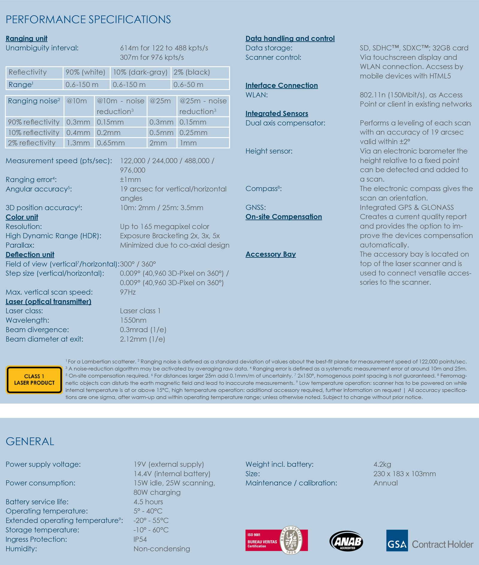
FARO Focus S350 Laser Scanner (New) - Sale! (Focus S350)
Easy handling of scanner control through its large and luminous touchscreen
$5,427.93 $6,098.80
The Faro Focus S 350 combines all benefits from FARO’s well-known Focus3D Laser Scanners with today’s most innovative features to perform laser scanning in both indoor and outdoor environments - truly mobile, fast and reliable. The FARO Focus S 350 provides the next level of laser scanning for all applications in industries like Construction, BIM/CIM, Public Safety and Forensics.
BENEFITS
Scanning in rough environments while providing protection from dust, debris and water splashes
Confident data quality through the on-site compensation
Reality-like scan data by increased distance accuracy and angular accuracy
Future-proof investment and expandability due to the integrated accessory bay
Easy handling of scanner control through its large and luminous touchscreen
FARO FOCUS S350 LASER SCANNER FEATURES
- ACCURACY
The FocusS now captures environments with increased accuracy regarding distance, dual axis compensator and angular measurement.
- TEMPERATURE
Extended temperature range allows scanning in challenging environments
- ON-SITE COMPENSATION
With the on-site compensation functionality users can verify and adjust the Focus S compensation on-site.
- IP RATING - CLASS 54
With the sealed design, the Focus S is certified with the industry standard Ingress Protection (IP) Rating and classified in class 54 against environmental influences.
- HDR PHOTO OVERLAY
The HDR camera captures detailed imagery easily while providing a natural color overlay to the scan data captured under extreme brightness gradients.
- ACCESSORY BAY
With this future-proof interface users can connect additional accessories to the scanner, which offers an option for user specific customization.
FARO Focus S 350 Laser Scanner, the latest ultra-portable enables you to capture fast, straightforward and accurate measurements of complex objects and buildings. The intuitive touch-screen of the Focus S models has been increased in size and clarity to deliver an extraordinary user experience. A built-in 8 mega-pixel, HDR-camera captures detailed imagery easily while providing a natural colour overlay to the scan data in extreme lighting conditions. Familiar traits such as light weight, small size and a 4.5-hour battery runtime per charge makes the Focus S Laser Scanner truly mobile for fast, secure and reliable scanning.
The Focus S 350 offers extra long range of 350m, with their sealed design, are certified via the industry standard Ingress Protection (IP) Rating, and classified in Class 54 for environmental protection. The devices are built to safeguard against intrusions such as dirt, dust, fog and rain as well as other outdoor elements which typically occur in challenging scanning conditions. In addition the laser scanner offers a future-proof interface to connect additional accessories to the scanner and provide a specific on-site compensation routine.
The FARO Focus S 350 is specially designed for outdoor applications due to its small size, extra light weight and extended scanning range. The Focus S 350 provides scanning results even in challenging environments, narrow job-sites, dusty or humid areas, in rain or direct sunlight applications. An on-site compensation tool allows data quality optimization on-site. Integrated GPS & GLONASS receiver enable easy positioning. HDR imaging and HD photo resolution ensure true-to-detail scan results with high data quality.
Remote scanning as well as almost limitless scan data sharing via SCENE Webshare Cloud make the laser scanning solution truly mobile.

FARO Focus S150 Plus Laser Scanner (New) - Sale! (Focus S150 Plus)
With several features have been reviewed and improved to make data capture easier for the user
$5,265.85 $5,916.69
FARO Focus S Plus series with EXTRA SPEED, the new models Focus S 150 Plus with several features have been reviewed and improved to make data capture easier for the user. Experience maximum measurement speeds with up to 2 million scan points per second!
Key benefits of the new Focus S Plus series
More efficient scanning process thanks to faster and more reliable on-site registration
Display of the scan progress thanks to status indicator
Tolerance control of the results at the touch of a button
Reliable data thanks to reduced noise
The Focus S Laser Scanner series offers advanced functionality. In addition to increased distance, angular accuracy, and range, the Focus S Plus scanners’ on-site compensation function ensures high-quality measurements, while external accessory bays and HDR functionality make the scanner extremely flexible. New long and medium range 3D laser scanners, with the new models FARO Focus S 150 Plus and FARO Focus S 350 Plus from FARO, several features have been reviewed and improved to make data capture easier for the user. Experience maximum measurement speeds with up to 2 million scan points per second!
Laser Scanners for Short, Medium and Long Range Applications
FARO Focus Laser Scanners are specifically designed for both indoor and outdoor measurements in industries such as Architecture, Engineering, Construction, Public Safety and Forensics or Product Design. All devices capture real world information used in the digital world to analyze, collaborate and execute decisions to improve and maintain the overall project and product quality.
The Focus S Laser Scanner series offers advanced functionality. In addition to increased distance, angular accuracy, and range, the Focus S and Focus S Plus scanners’ on-site compensation function ensures high-quality measurements, while external accessory bays and HDR functionality make the scanner extremely flexible.
The FocusS 150 Plus is a mid-range device offering precise scanning up to 150m. With their sealed design, both models are certified via the industry standard Ingress Protection (IP) Rating, and classified in Class 54 for environmental protection. The devices are built to safeguard against intrusions such as dirt, dust, fog and rain as well as other outdoor elements which typically occur in challenging scanning conditions. An addition the two laser scanners offer a future-proof interface to connect additional accessories to the scanner and provide a specific on-site compensation routine.
Features
Accuracy : Highest accuracy and range by using a combination of the most advanced sensor technologies
Rescanning of Distant Targets : The Scan Group feature identifies multiple areas to be rescanned with higher resolution to either perform accurate target detection or to capture smaller areas of interest with greater detail
IP Rating 54 and Extended Temperature Range : With the sealed design and certified with the industry standard Ingress Protection (IP) Rating, IP54, the Focus can be used in wet weather conditions at temperatures from -20°C to 55°C8
Compact and Portable : Focus Laser Scanners are the smallest and lightest devices in their performance class
On-Site Compensation : With the on-site compensation functionality, users can verify and adjust the Focus S compensation immediately before scanning, ensuring high-quality scan data and traceable documentation
On-Site Registration : During on-site data capture, the laser scanner immediately transmits scan data wirelessly to FARO SCENE for real-time scan processing and registration, providing efficiency and time savings
Benefits
Confidence in documented data-quality by traceable calibration and market-leading on-site compensation
Scan in challenging environments while providing protection from dust, debris and water splashes. Mount the Focus S scanner in an inverted position, such as under a ceiling of a hall
The Focus Laser Scanner portfolio offers the most economic 3Dscanning solution for all requirements and budgets
Minimum training effort is ensured by the intuitive and easy to operate touch-screen interface as well as hands-on and online tutorials
Efficient integration into existing software infrastructures and workflows are provided by interfaces to various standard CAD systems

$4,673.52 $5,251.15
Automatically pre-register point cloud data in the field to quickly conduct quality control checks, improve productivity and make better-informed decisions on site.
The Leica RTC360 3D reality capture solution empowers users to document and capture their environments in 3D, improving efficiency and productivity in the field and in the office through fast, simple-to-use, accurate, and portable hardware and software. The RTC360 3D laser scanner is the solution for professionals to manage project complexities with accurate and reliable 3D representations and discover the possibilities of any site.
Highly portable, highly automated, intuitive and designed for maximum productivity, the RTC360 solution efficiently combines the RTC360 a high-performance 3D laser scanner, Leica Cyclone FIELD 360 mobile-device app for edge computing for automatically registering scans in real time, and Leica Cyclone REGISTER 360 office software to integrate your 3D model seamlessly into your workflow.
Capture scans, including enriching High-Dynamic Range (HDR) imagery, in less than two minutes.
Automatically record your moves from station to station to pre-register your scans in the field without manual intervention.
Augment your data capture with information tags illustrating the opportunities for better planning, reflect site reality, and boost your teams’ situational awareness
Directly publish your captured data from Cyclone FIELD 360 to Leica TruView Cloud to quickly exchange project information prior to import and registration.
Fast
The Leica RTC360 laser scanner makes 3D reality capture faster than ever before. With a measuring rate of up to 2 million points per second and advanced HDR imaging system, the creation of coloured 3D point clouds can be completed in under two minutes. Plus, automated targetless field registration (based on VIS technology) and the seamless, automated transfer of data from site to office reduce time spent in the field and further maximise productivity.
Agile
Small and lightweight, the Leica RTC360 scanner’s portable design and collapsible tripod mean it’s compact enough to fit into most backpacks, ready to be taken anywhere. Once on-site, easy-to-use, one-button operation makes for fast, hassle-free scanning.
Precise
Low noise data allows for better images, resulting in crisp, high-quality scans that are rich in detail and ready for use in a range of applications. Combined with Cyclone FIELD 360 software for automated registration in the field, the Leica RTC360 scanner offers outstanding precision that can be checked on-site.
Pre-registraton in the field
As part of the RTC360 solution, the Cyclone FIELD 360 app links the 3D data acquisition in the field with the laser scanner and data registration in the office with Cyclone REGISTER 360. On-site the user can automatically capture, register and examine scan and image data. The user interface combines easy handling of complex calculations with a graphical user guidance that offers a remarkable user experience, also for novice users.
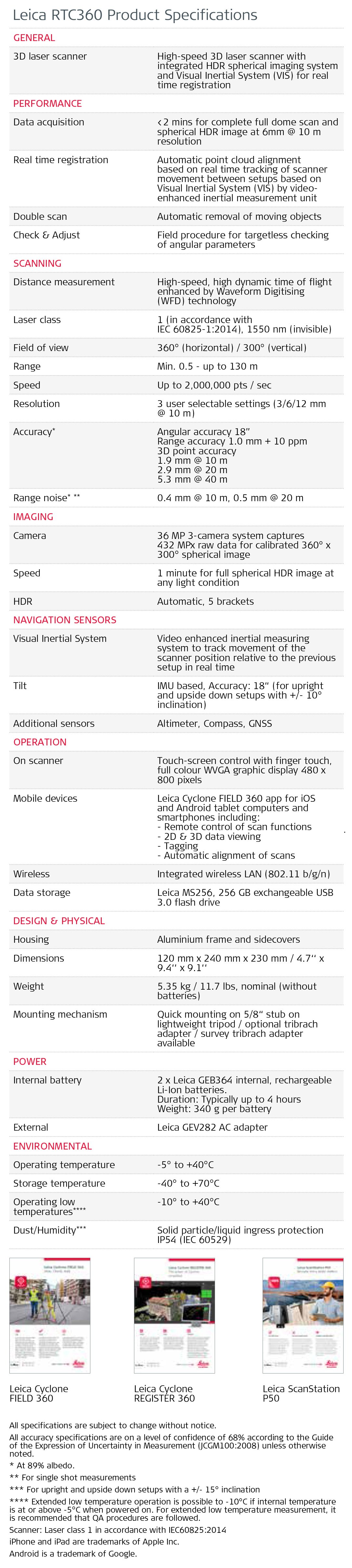
LEICA RTC360 SPECIFICATIONS
GENERAL
3D Laser Scanner: High-speed 3D laser scanner with integrated HDR spherical imaging system and Visual Inertial System (VIS) for real time registration
PERFORMANCE
Data acquisition: <2 mins for complete full dome scan and spherical HDR image at 6mm @ 10 m resolution
Real time registration: Automatic point cloud alignment based on real time tracking of scanner movement between setups based on Visual Inertial System (VIS) by video- enhanced inertial measurement unit
Double scan: Automatic removal of moving objects
SCANNING
Distance measurement: High-speed, high dynamic time of flight enhanced by Waveform Digitising (WFD) technology
Laser class: 1 (in accordance with IEC 60825-1:2014), 1550 nm (invisible)
Field of view: 360° (horizontal) / 300° (vertical)
Range: Min. 0.5 - up to 130 m
Speed: Up to 2,000,000 pts / sec
Resolution: 3 user selectable settings (3/6/12 mm @ 10 m)
Accuracy: Angular accuracy 18”
Range accuracy: 1.0 mm 10 ppm
3D point accuracy
1.9 mm @ 10 m
2.9 mm @ 20 m
5.3 mm @ 40 m
Range noise: 0.4 mm @ 10 m, 0.5 mm @ 20 m
IMAGING
Camera: 6 MP 3-camera system captures
432 MPx raw data for calibrated 360° x
300° spherical image
Speed: 1 minute for full spherical HDR image at any light condition
HDR: Automatic, 5 brackets
NAVIGATION SENSORS
Visual Inertial System: Video enhanced inertial measuring system to track movement of the scanner position relative to the previous setup in real time
Tilt: IMU based, Accuracy: 3‘ for any tilt
dditional sensors Altimeter, Compass, GNSS
OPERATION
On scanner: Touch-screen control with finger touch, full colour WVGA graphic display 480 x 800 pixels
Mobile devices: Leica Cyclone FIELD 360 app for iPad or
Android tablets including:
- Remote control of scan functions
- 2D & 3D data viewing
- Tagging
- Automatic alignment of scans
Wireless: Integrated wireless LAN (802.11 b/g/n)
Data storage: Leica MS256, 256 GB exchangeable USB 3.0 flash drive
DESIGN & PHYSICAL
Housing: Aluminium frame and sidecovers
Dimensions: 120 mm x 240 mm x 230 mm / 4.7‘‘ x 9.4‘‘ x 9.1‘‘
Weight: 5.35 kg / 11.7 lbs, nominal (without batteries)
Mounting mechanism: Quick mounting on 5/8“ stub on lightweight tripod / optional tribrach adapter / survey tribrach adapter available
POWER
Internal battery: 2 x Leica GEB361 internal, rechargeable
Li-Ion batteries.
Duration: Typically up to 4 hours
Weight: 340 g per battery
External: Leica GEV282 AC adapter
ENVIRONMENTAL
Operating temperature: -5° to 40°C
Storage temperature: -40° to 70°C
Dust/Humidity: Solid particle/liquid ingress protection IP54 (IEC 60529)
LEICA CYCLONE FIELD 360, VIEW, CHECK, ADD
View: As part of the Leica Geosystems Reality Capture 360 solution, the high- performance Leica Cyclone FIELD 360 mobile-device app is the perfect field companion for the Leica RTC360 3D laser scanner. With its intuitive user interface, remote scanner control and on-site point cloud display, navigation is a breeze - even for novice users – with full imagery and point cloud data delivered directly to your tablet using edge computing technology.
Check: Direct data access and visualisation are the foundation for quality control in the field; with Cyclone FIELD 360, automatically pre-registered point cloud data enables users to quickly conduct on-site quality control checks, improves productivity and makes for better-informed decisions in the field.
Add: For improved registration in Leica Cyclone REGISTER 360 post-processing, and to add extra value and information to 3D data, Cyclone FIELD 360 enables on-site tagging of measurements, videos, images, text or voice files to the point cloud geometry simply by using your table.
LEICA CYCLONE FIELD 360 SPECIFICATIONS
GENERAL
iOS or Android app In-the-field app for remote scanner control,
data management, quality control, data tagging
and automatic pre-registration on-site
SCANNER CONTROL
Remote scanner control with access to all control features
DATA MANAGEMENT
Create, edit and delete scan jobs
DATA COMMUNICATION & TRANSFER
Communication Bi-directional wireless communication between scanner and table
Transfer
QUALITY CONTROL
Automatic transfer of scan data from scanner to tablet; automatic synchronisation of all app created data from tablet to scanner
Point cloud navigation: Navigate single and registered point clouds in 2D map view, 360° panoramic view or in full 3D view
Point cloud display: Display point clouds in full HDR colour, rainbow intensity or grey-scale mapping
Measurement: Take and tag measurements within the point cloud
DATA TAGGING
Add image, video, voice, text or any other file-based tags to point cloud
PRE-REGISTRATION
Auto alignmen: Visual Inertial System (VIS) technology based automated alignment of scan setups for targetless cloud-to-cloud registratiON
Visual alignment: Move and rotate scan setups for a quick visual alignment for cloud-to-cloud registration
INTEROPERABILITY
Sensor hardware: Leica RTC360 laser scanner
Cyclone software
Leica Cyclone REGISTER 360 1.5 or higher, requires active REGISTER 360 license foractivation
SYSTEM REQUIREMENTS
Platform: Android tablet computer running on Android 6.0
or higher, e.g. Samsung Galaxy Tab S3
Apple iPad tablet computer running on iOS 11.1
or higher, e.g. iPad Pro with 10.5“ scree
INCLUDED:
Leica RTC360 Laser Scanner
864 515 Cyclone REGISTER 360 Permanent
4X GEB361 Lithium-Ion battery, 11.1V, 5.6Ah, rechargeable
2X Leica MS256 Industrial USB 3.0 Stick 256GB
Leica GST80 Tripod for RTC360
636 767 Leica RTC360 Rain Cover
Leica GVP736 Backpack for RTC360
Leica GVP730 Transport Container for RTC360
Leica RTC360 USB Documentation Card
Leica GAD120 Tribrach Adapter
Leica GDF323 Tribrach
GKL341 Multi-bay charger Prof 5000, Charges up to 4 batteries, including power cable
310.13-Li-Ion batteries GEB211, GEB212, GEB221, GEB222, GEB241, GEB242, GEB331 and GEB361
AC adapter included, AC power cable to charger for Rugby/Javelin

Thermo Scientific Niton XL5 Plus Handheld XRF Analyzer (New) - Sale! (Niton XL5 Plus)
Ideal for specific applications where faster analysis and lower detection limits are needed
$5,776.08 $6,417.87
Confidently perform elemental analysis with the Thermo Scientific™ Niton™ XL5 Plus handheld XRF analyzer; it delivers unprecedented performance even for lightweight elements. Identify pure metals and alloys, detect tramp elements, or obtain geochemical data. Industrial businesses rely on the Niton XL5 Plus analyzer for more than just low detection limits. It generates fast results and offers great versatility such as the ability to scan a broad range of materials with a single analyzer.
Features
- 5W X-ray tube
- Proprietary large area drift detector for light element detection (Mg, Al, Si, P, S)
- Lightweight design (2.8 lbs/ 1.3 kg)
- Miniaturized nose
- WiFi enabled
- Macro and micro cameras
- Hot swap battery
- Tilting, color touchscreen
- Directional keys
- Password protected security
- IP54 certified (splash/dust proof)
Applications
- Verification of metals and alloys in manufacturing operations
- Non-destructive field inspections for positive material identification
- Point-and-shoot sorting at scrap recycling operations
- Coating thickness measurements for single or binary metal layers
- Precious metal assay of bullion and jewelry
- Real-time geochemical analysis for mining exploration
- On-site heavy metal screening of polluted soils
- Screening of hazardous substances in consumer goods
- Custom applications on demand
Specifications
Data Storage | 512 MB internal system memory / 16 GB industrial grade storage; Stores approximately 130,000 readings with spectra (fewer if macro and micro images are saved) |
Data Transfer | WiFi, USB-c |
Description | Niton XL5 Plus Handheld XRF Analyzer |
Detector Type | High count rate, high resolution, extra large area silicon drift detector (1μm graphene window). Detector ProGuard protection included. |
Display Type | Tilting, color, resistive touchscreen display |
Optional Accessories |
|
Power Consumption | 12V lithium-ion battery, or 12V DC, 3A, 3.6W power supply. Hot swap functionality keeps analyzer powered during battery replacements. |
Security Features | Password-protected user security |
Standard Accessories |
|
System Details | Built-in standardization and health check verify system integrity and operating conditions |
Weight (English) | 2.8 lb. with battery |
Weight (Metric) | 1.3 kg with battery |
Data Entry |
|
Licensing | Varies by region. Contact your local distributor. |
Dimensions (L x W x H) | 9.54 x 8.19 x 2.67 in. (24.23 x 20.8 x 6.78 cm) |
Languages | English, Chinese, Spanish, Portuguese, Russian, Japanese, German, Korean, French, Turkish, Italian |
X-Ray Source Type |
|
Spot Size |
|
Libraries | Default alloy libraries based on SAE, AISI, ASTM, AA, DIN, GB standards. Users may create, clone and edit libraries. |
Operating Environment |
|
Software | Support software: NitonConnect PC software |
Global Positioning System | Internal GPS and optional external GPS (via Bluetooth) GPS data included with sample information. |
Operating System | Linux |
Certifications/Compliance | CE, RoHS, FCC, Industry Canada, Safety to IEC 61010-1:2010 |
Unit Size | Each |

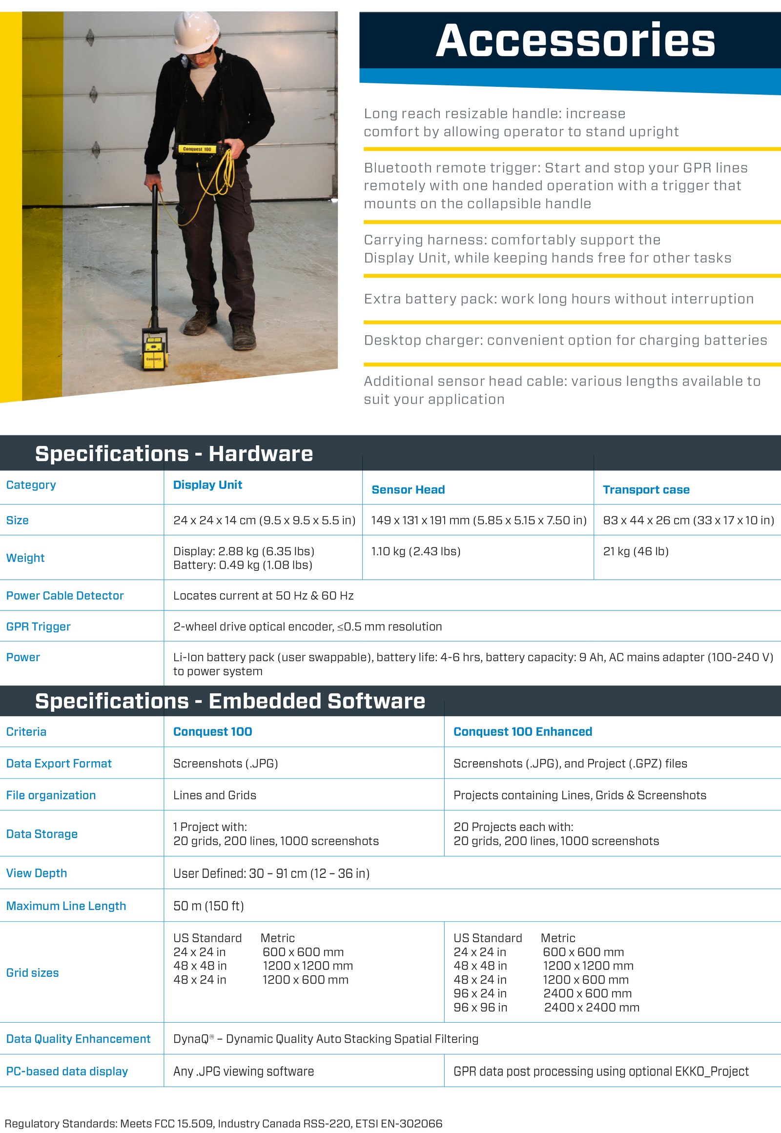
Sensors and Software Conquest 100 Ground Penetrating Radar (New) - Sale! (Conquest 100)
Allows you to get rapid, reliable results and reduce the need for destructive testing
$4,613.09 $5,125.65
Unlock a world of subsurface information with one quick scan.
Conquest® 100 allows you to get rapid, reliable results and reduce the need for destructive testing. It is a light, portable device that provides a fast, non-invasive method to gain accurate insights of objects below the concrete surface, even on a curved surface or column.
Conquest® 100 GPR increases safety by detecting rebar, post-tension cables, metallic and non-metallic conduits as well as current-carrying wires embedded in concrete. Once your concrete scan is complete, the system allows you to e-mail information directly from the field in the form of a Wi-Fi mini-report. With the Conquest® 100 Enhanced, you also have the option to add the powerful optional EKKO_Project™ Software to view your data and make client-ready reports in minutes once back in the office.
Features:
High-Resolution Touchscreen: See targets clearly with intuitive on-screen operation
Easy Reporting: Transfer information wirelessly to your smartphone using Wi-Fi
Optional EKKO_Project™ PC Software: Our all-inclusive software solution for managing, displaying, processing and interpreting GPR data.
Swappable Li-Ion Battery: Never lose time with long-lasting swappable batteries.
All-in-one transportation case.
Collect data in a comfortable standing position using the optional resizable handle for the Sensor Head and carry harness for the Display Unit.
Bluetooth remote triggering for easy one-handed operation when using the Conquest® 100 collapsible handle.
Data Collection Modes:
Line Scan
Perform reconnaissance surveys to gain real-time assessment of targets embedded in concrete. Pin-point targets with the backup arrow.
Perform accurate measurements
Classify targets with color coded field interpretations by simply touching the screen
Display position and depth of targets with the touch of a finger
Grid Scan
Perform detailed area mapping to generate on-site 3D images to better visualize embedded objects in complex sites. Select from pre-set grid sizes with varying resolution levels.
Safe Coring, Drilling and Cutting
Detect embedded objects before cutting or coring:
Create detailed scans of concrete floors, decks, columns, walls and ceilings to detect conduits beneath slab-on-grade
On-screen drill locator:
Target coring position and cut with confidence reducing the risk of hitting a conduit.
Color-coded interpretations:
Classify targets with field interpretations right from your display unit
Power Cable Detector (PCD)
Locate power cables that are embedded in concrete within your survey area to mitigate any potential risks when construction works needs to be done. The standard PCD feature built-in the Conquest® 100 augments GPR imaging allowing the user to detect current-carrying utility lines.

Thermo Scientific Niton XL3t Ultra XRF Analyzer (New) - Sale! (Niton XL3t Ultra)
Ideal for specific applications where faster analysis and lower detection limits are needed
$4,608.27 $5,120.30
Find elusive oil and gas deposits and avoid drilling in the wrong spot, which is expensive and time consuming. The Thermo Scientific™ Niton™ XL3t Ultra Analyzer provides rapid sample analysis in the field so that you can quickly find where deposits are and which ones will prove the most productive. This high-functioning tool offers the superior light element detection required for gas shale applications without helium purge or vacuum. It is also the instrument of choice for positive material identification, delivering exceptional elemental analysis and alloy grade identification in seconds.
The Niton XL3t Ultra Analyzer is ideal for specific applications where faster analysis and lower detection limits are needed. The Ultra advantage is a 45mm2 Silicon Drift Detector (SDD) that delivers vast improvements in sensitivity and measurement times– as much as 10-times faster than conventional Si-PIN detectors, and up to 3-times more precise than conventional silicon drift detectors. With its faster analysis, higher precision, and the ability to measure light elements without helium or vacuum assistance, it is the ideal instrument for the following applications:
Oil and Gas Exploration
- Upstream exploration and production
- Rapid, on-site chemical analysis of rocks, cuttings, and cores that can be used for identifying formations and determining mineral composition of the rock
- Inferring mineralogical properties favorable to oil and gas production from data collected in real-time
Mining Exploration
- Early stage exploration: soil survey and outcrop evaluation
- Advanced exploration and drilling: trend analysis to identify decreasing or increasing pattern of elements of interest to make “continue” or “stop” drilling decisions onsite
- Ore deposit modeling/mapping
Positive Material Identification (PMI)
- Fast, accurate alloy analysis and positive alloy grade identification
- Incoming materials inspection, in-process verification, and final product inspection
- Recover lost material traceability
- Isolate finished welds to validate filler material and dilution
- Confirm the integrity of process process piping, valves and reaction vessels
SPECIFICATIONS
Analytical Range | Standard Analytical Range: Up to 30 elements from Mg to U (varies by application)Optional Light Elements; Ultra-low light element detection via He purge |
Available Analytical Modes | Mode (Varies by application)Alloy Modes: Metal Alloy, Electronics Alloy, Precious MetalsBulk Modes: Soil, Mining, TestAll™Plastic Modes: RoHS Plastics, Toy & Consumer Goods Plastics, TestAll, Painted ProductsCustom Modes: Upon request (based on application feasibility) |
Data Storage | Internal >10,000 readings with spectra |
Data Transfer | USB, Bluetooth, and RS-232 serial communication |
Description | Niton XL3t Ultra Analyzer |
Detector Type | Geometrically Optimized Large Area Drift Detector |
Display Type | Tilting, color, touch-screen display |
Item Description | Niton XL3t Ultra Analyzer |
Height (English) | 3.75 in. |
Height (Metric) | 95.5 mm |
Length (English) | 9.60 in. |
Length (Metric) | 244 mm |
Width (English) | 9.05 in. |
Width (Metric) | 230 mm |
Optional Accessories | WeldSpot 3 mm small-spot collimation, portable test stands, stationary (bench-top) test stand, mobile test stand, Thermo Scientific™ Extend-a-Pole™ extension pole, weld mask, Thermo Scientific™ HotFoot™ hot surface adapter, soil testing guard |
Security Features | Password-protected user security |
Standard Accessories | Integrated CCD camera for locating and storing images, locking carrying case, shielded belt holster, two lithium-ion battery packs, 110/220 VAC battery charger/AC adaptor, PC connection cables (USB and RS-232)Thermo Scientific™ Niton Data Transfer (NDT™) PC software, safety lanyard, check samples/standards |
System Details | Resolution: < 185 eV @ 60,000 cps @ 4µ sec shaping time |
Tube Type | Ag anode (6-50 kV, 0-200 µA max) |
Weight (English) | 3 lbs. |
Weight (Metric) | 1.3 kg |
System Electronics | 533 MHz ARM 11 CPU300 MHz dedicated DSP80 MHz ASICS DSP for signal processing4096 channel MCA32 MB internal system memory/128 MB internal user storage |
Data Entry | Touch-screen keyboardUser-programmable pick listsOptional wireless remote barcode reader |
Licensing | Varies by region. Contact your local distributor. |
Dimensions (L x W x H) | 9.60 x 9.05 x 3.75 in. (244 x 230 x 95.5 mm) |
Certifications/Compliance | CE, RoHS |

GeoMax Zoom75 Robotic Total Station (New) - Sale! (Zoom75)
Solution that makes it easy for you to start digitising your construction site
$4,504.95 $5,005.50
The robotic total station solution that makes it easy for you to start digitising your construction site.
The Zoom75 robotic TPS is a smart, affordable choice for both novice and experienced surveyors. As a reliable one-person total station, the Zoom75 has an optional long-range Bluetooth handle, along with the GeoTRAil function that finds your prism based on the GNSS position transferred from your field controller. Combined with the X-PAD field software, the user-friendly and flexible solution makes it easy to start digitising your construction site.
Modern Data capturing & handling
No more paper plans. Upload your plans onto the X-PAD Ultimate field software or into the TPS, and conveniently edit the CAD drawings on-site on the big screen of the GeoMax robotic total stations. Big files can be handled easily and fast thanks to the strong performing processor of the Zoom75. With the unique X-TILT feature and the Zenius800, inaccessible points are no longer a challenge. X-TILT automatically calculates a point position by tilting the tablet attached to the prism pole, in two directions.
Seamless workflow with maximum flexibility
X-PAD software, GeoMax field controllers and the Zoom75 robotic TPS are carefully chosen and developed to enable a carefree and efficient workflow. X-PAD gives you the flexibility to choose your preferred operating system and field controller as it is available as fully-featured Android ™ and Windows ® field software running on a multitude of field controllers.
One-person total station
Equipped with the long-range Bluetooth® handle, the Zoom75 transforms into a true one-person total station. It supports the advanced prism search, based on the GNSS position of the controller, mounted on the pole. As there is no need for special, expensive and power-consuming active prisms, this total station is ideal on any worksite. Zoom75 keeps your pole lightweight and convenient to carry all survey-day long!
Convenient and safe data management
X-PAD 365, the web-based GeoMax cloud platform, was created to address data management and collaboration challenges surveyors and construction professionals meet every day. Working with the Zoom75, data can be accessed, stored, and shared via the X-PAD 365 File Manager. Your data is always safe, thanks to automatic backups. Furthermore, the Collaborative Survey and Stakeout feature allows several users to work on the same surveying or stakeout project together, sharing real-time surveyed points and drawings and immediately seeing their progress.
Keep X-PAD at its best - select your service
X-PAD Ultimate software is always maintained without any extra costs. By keeping your X-PERT service active, you can continuously profit from the latest software improvements.
Reliable partner
Hexagon is known for driving innovation and technological progress. As a part of this group, GeoMax can guarantee that its solutions work when you do.

FARO Focus S150 Laser Scanner (New) - Sale! (Focus S150)
A mid-range device offering precise scanning up to 150m
$4,947.99 $5,497.77
FARO LASER SCANNER FOCUS S150 | THE WORLD'S MOST POPULAR TERRESTRIAL LASER SCANNER WITH ULTRA-HIGH ACCURACY AND INGRESS PROTECTION
The ultra-portable Focus S 150 enables fast, straightforward and ultra-high accurate measurements of objects and buildings. It records architectural façades, complex structures, production and supply facilities, accident sites, and large-volume components delivering realistic and true-to-detail scan results with a range of 150m per scan. This Faro Focus S 150 laser scanner enable to capture fast, straightforward and accurate measurements of complex objects and buildings. The intuitive touch-screen of the Focus S models has been increased in size and clarity to deliver an extraordinary user experience. A built-in 8 mega-pixel, HDR-camera captures detailed imagery easily while providing a natural color overlay to the scan data in extreme lighting conditions. Familiar traits such as light weight, small size and a 4.5-hour battery runtime per charge makes the Focus S Laser Scanner truly mobile for fast, secure and reliable scanning.
The Focus S 150 is a mid-range device offering precise scanning up to 150m. With their sealed design, both models are certified via the industry standard Ingress Protection (IP) Rating, and classified in Class 54 for environmental protection. The devices are built to safeguard against intrusions such as dirt, dust, fog and rain as well as other outdoor elements which typically occur in challenging scanning conditions. An addtion the two laser scanners offer a future-proof interface to connect additional accessories to the scanner and provide a specific on-site compensation routine.
Remote scanning as well as almost limitless scan data sharing via SCENE Webshare Cloud make the laser scanning solution truly mobile.
Features of the new Focus S Laser Scanner
The most recent Focus S series combines all benefits from FARO’s well-known Focus3D Laser Scanners with today’s most innovative
features to perform laser scanning in both indoor and outdoor environments – truly mobile, fast and reliable. Like the latest devices from the Focus X series they support High Dynamic Range (HDR) photo recording.
What are the functions of HDR?
The HDR laser scanner models record HDR imagery. HDR means high dynamic range and is a technique to capture images with multiple exposure rates and merging them into a single HDR image layer. This HDR image provides additional details in dark or bright areas, which would have been lost in a standard image. These HDR images will be mapped onto the point cloud data generated by the laser scanner.
Main benefits:
Reliable life-like visualization, even under extreme lighting conditions and large distance
Safe and fast as-built data capturing with superior colour detail
Reduced complexity by integrated scanning and imaging workflow for all kinds of scanning tasks