Special Offers

Trimble RTS 673 Robotic Total Station Kit (New) - Sale! (RTS 673)
Designed for general and specialty contractors that require quality, accuracy and optimum field performance
$3,013.32 $4,836.79
This robotic total station is designed for general and specialty contractors that require quality, accuracy and optimum field performance.
The Trimble® RTS Series Robotic Total Stations help contractors perform layout tasks significantly more efficiently than with conventional mechanical systems for residential and building construction. Designed specifically for concrete, MEP, and general construction contractors, the Trimble RTS Series Robotic Total Stations offer construction-specific functionality and one-person operation so you can perform all jobsite layout and measurement tasks for maximum flexibility and cost savings.
KEY FEATURES:
- Total Station Type: Robotic
- DR HP EDM
- 3″ Angular Accuracy
- Telescope
- Track Light
- Robotic communication link: 2.4 GHz radio
- Robotic radio communication range: 500 – 700 m (1,640 – 2,297 ft)
- Distance measurement accuracy (Prism Mode): ±2 mm 2 ppm (0.01 ft 2 ppm)
- Reflectorless DR Measuring: Yes – 120m
- One person layout
- Prism & Laser Layout
- Easy-to-follow user interface shortens learning curve and faster operation
- Rugged design, withstands tough jobsite conditions and minimzes downtime due to repair
When combined with the Trimble Field Link or Trimble Field Link for MEP, the Trimble RTS Series Robotic Total Stations significantly increase accuracy, reliability, and productivity.
APPLICATIONS:
- Layout of control
- Checking or tying into property boundaries
- Layout of excavation lines
- Layout of concrete forms and anchor bolts
- As-built checks
- Layout of control lines on concrete pad for subcontractor
- Layout of hangers, sleeves and underground pipe
- Light topographical measurements
In The Box
1 - Trimble RTS673 3" DR HP Robotic Total Station
- Internal 2.4 GHz Radio w/ Antenna
- Accuracy: Within 5/32" or 4.2mm at 500ft
2 - Trimble Total Station Batteries
1 - Dual Charger w/ Power Supply
1 - 360° Prism
1 - Trimble Transport Case

FARO Freestyle3D X Handheld Scanner (New) - Sale! (Freestyle3D X)
Especially designed for challenging scanning projects which require highest accuracy
$4,035.55 $6,305.55
The FARO Scanner Freestyle3D X is especially designed for challenging scanning projects which require highest accuracy. It is suitable for all applications in which demanding projects must be quickly scanned from various perspectives. The high-precision 3D scan data can easily be imported into all commonly used software solutions for architecture, accident reconstruction, civil engineering, construction, facility management, forensics or industrial manufacturing.
Faro Freesytle 3D X Application
- Architecture & Interior Design
- Measurements of complex structures and objects
- Project supervision
- Deformation monitoring
- Quality control
- Restoration & 3D Modelling
- Area construction progress monitoring
- Built environment
- Free-form components inspection
- Deformations control
- Reverse engineering
- Restoration & Conservation
- Construction & Facility Management
- Documentation
- Planning of structural alterations
- Re-planning of technical modifications
- Reconstruction
- Forensic
- Crime scenes investigation & analysis
- Digital proof collection
- Accessibility
- Body mapping
- Blood spatter analysis
- Fire Investigation
- Accident Reconstruction
- Traffic accident investigation & analysis
- Passive safety of cars
- Collision reconstruction
- Digital proof collection
- Digital accessibility
Features:
- Xtra accuracy: The verifiable accuracy of 1mm enables you to carry out highly challenging scanning projects.
- Optional on-site calibration: The device can be easily calibrated on-site ensuring high quality data. A PDF report with key data permits maximum and verifiable confidence in the acquired data.
- Automatic flash: The new auto mode automatically activates and de-activates the built-in LED light depending on the existing light conditions.
- Real-time point cloud visualization: The real-time point cloud visualization supports the intuitive data acquisition, even for untrained operators.
- Up to 8m³ scanning volume: The extensive scan volume boosts productivity by reducing scan time.
- Best point filter: The new best point filter minimizes the noise and allows to get optimum data quality.
- 3D point accuracy*: ≤ 1.0mm
- Indoor scanning volume: Up to 8m³
- IP rating: IP52**
- Operating temperature range: 0 – 40°C
Package includes :
- Faro Freesytle-3D X Scanner
- Tablet Surface Pro 3 (Microsoft)
- License Scene (Capture & Process) with 1 year Maintenance contract
- MicroSD card, USB card reader
- Calibration plate
- Cleaning kit
- Rugged Transport Case
- 1 Year manufacturer warranty

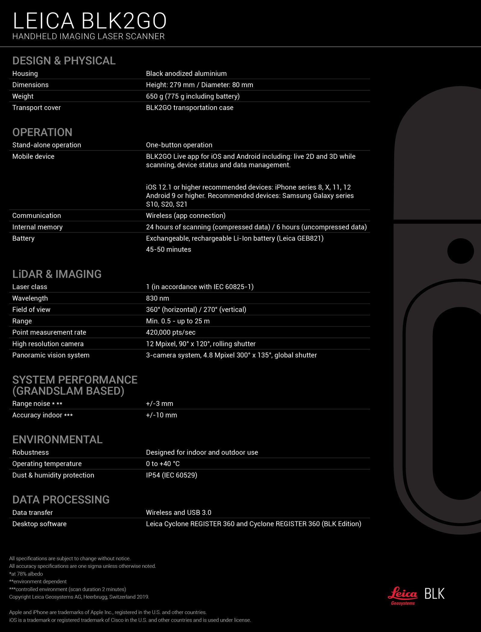
Leica BLK2GO Handheld Imaging Laser Scanner (Used) - Sale! (BLK2GO)
In excellent working condition
$4,540.35 $6,985.15
FEATURES
Simple One button is all you need to control the BLK2GO. Turn it on, walk, and the BLK2GO takes millions of accurate measurements to recreate the space around you in 3D.
Sleek: A masterpiece of cutting-edge engineering design.
Award Winning: The winner of multiple industry awards including CES Best of Innovation 2020, the BLK2GO is compact, lightweight, and so easy to use
Grab & Go: The BLK2GO drastically reduces the time needed to plan and scan on-site, and it doesn’t need a tripod or a trained operator
Model with Confidence: BLK2GO data is the foundation for accurate floorplans, BIM models, and 3D visualizations.
GrandSLAM: BLK2GO GrandSLAM technology simplifies mapping spaces in real-time.
Applications: BIM, Construction, Architecture, Archaeology, 3D modelling, Interior design, Film sets, Virtual reality, Visual effects, Game design.
SPECS:
Dual Axis Lidar Home: The smallest dual axis LiDAR available with best-in-class accuracy, enclosed in a fully protected and encapsulated dome that scans up to 420,000 points per second. Both axes constantly spin while scanning.
Multicamera Vision System: The BLK2GO’s vision system is a 12-megapixel detail camera for brilliant high-contrast imagery plus three panoramic cameras for visual navigation via SLAM, point cloud colourisation and capture of panoramic imagery.
The Grandslam: The GRANDSLAM (Simultaneous Localization and Mapping) is a combination of high-speed dual axis LiDAR, multi-camera vision system and an inertial measurement unit that makes the BLK2GO self-navigating.
Lightweight Aluminium Construction: Weighing in 775 grams (1.7 lbs.) with battery, the BLK2GO’s matte-finish aluminum construction allows for excellent dexterity and freedom of movement.
Smart Handle: The BLK2GO’s handle contains WLAN connectivity, a rechargeable battery capable of 45 minutes of continuous scanning, data storage for six hours of scans, a USB-C port for fast data transfer and edge computing.
Advanced Lightguide: The light guide that encircles the BLK2GO is simple, intuitive and communicative to users of all skill levels. It provides user guidance while scanning and communicates the device status and data quality.
** The expert said that the Leica BLK2GO more accurate for flexibility and speed against the Leica BLK360 and Leica RTC360.
INCLUDES:
- 1x BLK2GO Scanner
- 1x BLK2GO Transportation Case
- 3x GEB821 Li-Ion Battery
- 1x GKL821 Multicharger incl. AC-Adapter
- 1x BLK2GO Table Stand
- 1x GEV278 USB C Cable
- 1x BLK2GO Wrist Strap
- 1x BLK2GO Maintenance Plug
- 1x Cover Eject Pin
- 1x BLK2GO Quick Guide
- 1x BLK2GO Live App Info Card
- 1x BLK2GO USB Documentaton Card

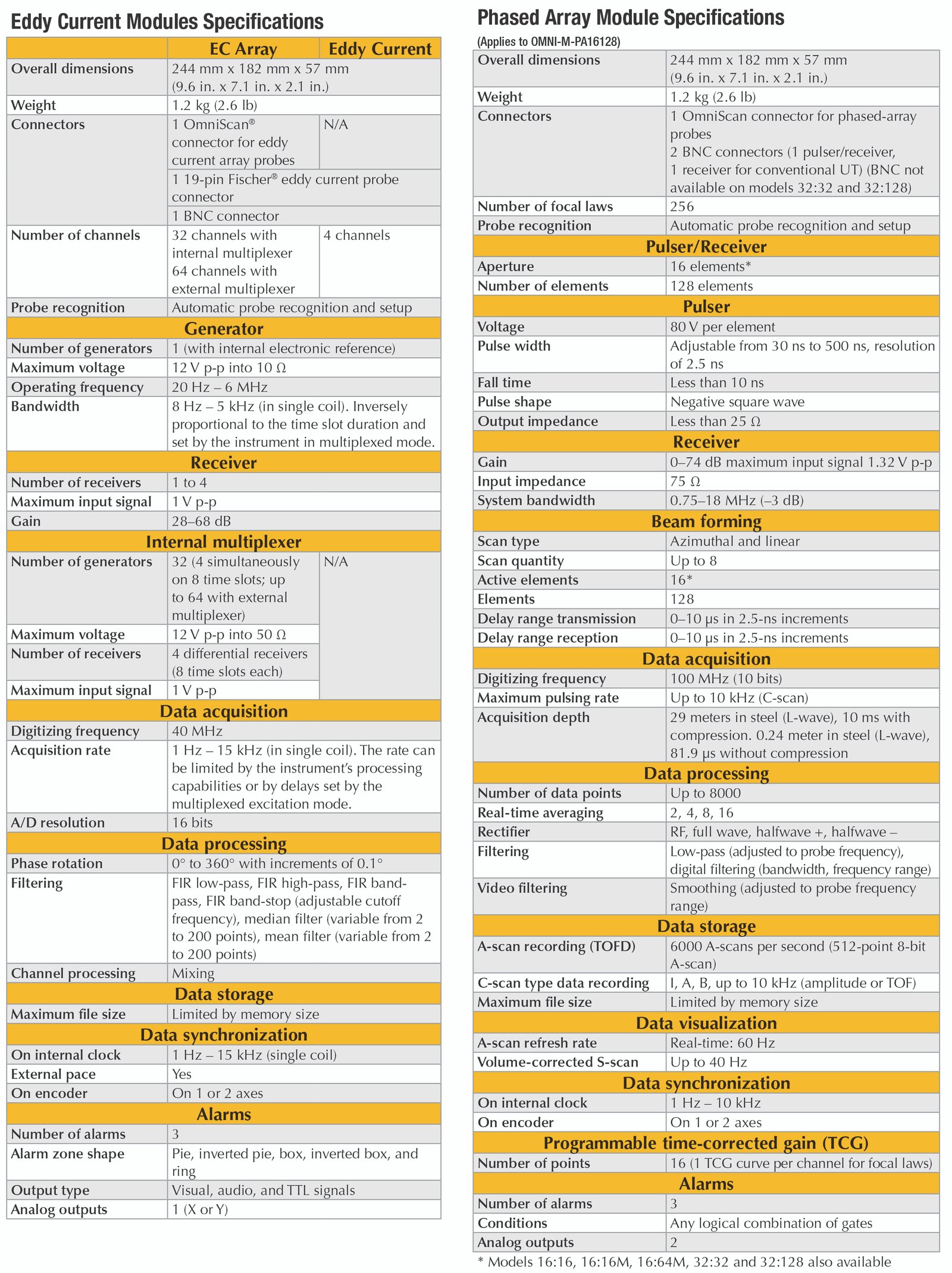
Olympus Omniscan MX2 16:128 Phased Array Flaw Detector (New) - Sale! (Omniscan MX2)
More than an Instrument-A Solution Provider
$4,038.65 $6,213.30
The result of over 10 years of proven leadership in modular NDT test platforms, the OmniScan MX has been the most successful portable and modular phased array test instrument produced by Olympus to date, with thousands of units in use throughout the world.
Olympus now offers a new PA module with TOFD, a new UT module, as well as new software programs (NDT SetupBuilder and new OmniPC version) that expand the capabilities of the successful OmniScan MX2 platform and improve the workflow efficiency of nondestructive testing inspections.
Building on a Solid Basis
This second generation OmniScan MX2 increases testing efficiency, ensuring superior, advanced AUT application performance with faster setups, test cycles, and reporting, in addition to universal compatibility with more than 10 phased array and ultrasound modules. Designed for NDT experts, this high-end, scalable platform delivers true next-generation NDT performance.
The OmniScan MX2 offers a high acquisition rate and new powerful software features for efficient manual and automated inspection performance—all in a portable, modular instrument.
Faster Is Better!
Powerstart your day with the OmniScan MX2. The OmniScan MX2 simplifies and speeds up the setup process with its intuitive step-by-step Wizard, so you can start testing quickly. Featuring the industry-standard phased array user interface with faster-than-ever performance, a bigger and brighter 10.4 in. (26.4 cm) screen, new and unique intuitive touch-screen capabilities, and faster data transfer, the MX2 enables you to get to your next inspection quicker.
More than an Instrument-A Solution Provider
The OmniScan MX2 is an important part of your inspection solution, and can be combined with other critical components to form a complete inspection system. Olympus offers a complete product range that includes phased array probes, scanners, analysis software, and accessories, all of which are integrated and packaged into rapidly deployable, application-specific solutions for a quick return on your investment. In addition, Olympus offers a high-quality global calibration and repair service, backed by a team of phased array application experts to ensure that you get the support you need.
Pressure Vessel Weld Inspection
A complete inspection of pressure vessel welds can be performed in a single scan using an OmniScan PA and manual scanner such as the HSMT series or a motorized scanner like the WeldROVER. By combining TOFD and PA in a single inspection pass, a significant reduction in inspection time can be achieved as compared with conventional raster scanning or radiography. Furthermore, inspection results are available immediately, enabling you to detect problems with welding equipment and fix them right away.
Composite Inspection
Parts made of laminate composite materials pose an inspection challenge due to their various shapes and thicknesses.
Olympus offers complete solutions for the inspection of carbon-fiber-reinforced polymer structures. These solutions are based on the OmniScan flaw detector, the GLIDER™ scanner, and dedicated probes and wedges designed for CFRP flat panel and radius inspection.
Weld Inspection of Small-Diameter Pipes
When coupled with the COBRA manual scanner, the OmniScan flaw detector is capable of inspecting pipes ranging from 0.84 in. OD to 4.5 in. OD. With its very slim design, this manual scanner is able to inspect pipes in areas with limited access. Adjacent obstructions such as piping, supports, and structures can be as close as 12 mm (0.5 in.).
Manual and Semiautomated Corrosion Mapping
The OmniScan PA system with the HydroFORM scanner is designed to offer the best inspection solution for detecting wall-thickness reductions resulting from corrosion, abrasion, and erosion. In addition, this system detects mid-wall damage, such as hydrogen-induced blistering and manufacturing-induced delamination, and clearly differentiates such anomalies from loss-of-wall-thickness.
For this application, phased array ultrasound technology offers superior inspection speed, data point density, and detection.
Modular Instrument
A Platform that Evolves as your Needs Grow
Designed to secure both your current and future phased array investments, the OmniScan MX2 houses more than 10 different Olympus modules. You can be confident that you will get the most out of your investment as specifications will continue to evolve with your needs through constant software updates.
State of the Art PA2 and UT2 Modules
As a world leader in phased array technology, Olympus has released a new line of modules compatible with MX2 instrument.
PA2
The new phased array offer-led by the new innovative PA2 modules, features multiple improvements, such as:
Best Phased Array and TOFD Signal Quality Ever
- Better signal-to-noise ratio
- More powerful pulsers
- 64 pure gray tone
More Multi-group Capabilities
- Ability to use PA and UT channels simultaneously
General Hardware Improvements
- Higher operating temperatures (45 °C)
- New OmniScan probe connector with quick latch system
- Designed for IP66 environmental rating
- Extended autonomy on batteries
UT2
The new conventional ultrasound module features the same UT-channel technology as the PA2 modules, but offers twice as many channels.

Olympus Omniscan MX2 PA Flaw Detector (Used) - Sale! (Omniscan MX2)
More than an Instrument! Very good condition and tested working!
$3,196.16 $4,917.17
The OmniScan MX2 increases testing efficiencies, ensuring superior manual and advanced AUT application performance with faster setups, test cycles, and reporting, in addition to universal compatibility with all phased array and ultrasound modules: past, present and future. Designed for NDT leaders, this high-end, scalable platform delivers true next-generation NDT performance.
The result of over 10 years of proven leadership in modular NDT test platforms, the OmniScan MX has been the most successful portable and modular phased array test instrument produced by Olympus to date, with thousands of units in use throughout the world.
Olympus now offers a new PA module with TOFD, a new UT module, as well as new software programs (NDT SetupBuilder and new OmniPC version) that expand the capabilities of the successful OmniScan MX2 platform and improve the workflow efficiency of nondestructive testing inspections.
Building on a Solid Basis
This second generation OmniScan MX2 increases testing efficiency, ensuring superior, advanced AUT application performance with faster setups, test cycles, and reporting, in addition to universal compatibility with more than 10 phased array and ultrasound modules. Designed for NDT experts, this high-end, scalable platform delivers true next-generation NDT performance.
The OmniScan MX2 offers a high acquisition rate and new powerful software features for efficient manual and automated inspection performance—all in a portable, modular instrument.
Faster Is Better!
Powerstart your day with the OmniScan MX2. The OmniScan MX2 simplifies and speeds up the setup process with its intuitive step-by-step Wizard, so you can start testing quickly. Featuring the industry-standard phased array user interface with faster-than-ever performance, a bigger and brighter 10.4 in. (26.4 cm) screen, new and unique intuitive touch-screen capabilities, and faster data transfer, the MX2 enables you to get to your next inspection quicker.
More than an Instrument - A Solution Provider
The OmniScan MX2 is an important part of your inspection solution, and can be combined with other critical components to form a complete inspection system. Olympus offers a complete product range that includes phased array probes, scanners, analysis software, and accessories, all of which are integrated and packaged into rapidly deployable, application-specific solutions for a quick return on your investment. In addition, Olympus offers a high-quality global calibration and repair service, backed by a team of phased array application experts to ensure that you get the support you need.
Pressure Vessel Weld Inspection
-A complete inspection of pressure vessel welds can be performed in a single scan using an OmniScan PA and manual scanner such as the HSMT series or a motorized scanner like the WeldROVER. By combining TOFD and PA in a single inspection pass, a significant reduction in inspection time can be achieved as compared with conventional raster scanning or radiography. Furthermore, inspection results are available immediately, enabling you to detect problems with welding equipment and fix them right away.
Composite Inspection
-Parts made of laminate composite materials pose an inspection challenge due to their various shapes and thicknesses. Olympus offers complete solutions for the inspection of carbon-fiber-reinforced polymer structures. These solutions are based on the OmniScan flaw detector, the GLIDER™ scanner, and dedicated probes and wedges designed for CFRP flat panel and radius inspection.
Weld Inspection of Small-Diameter Pipes
-When coupled with the COBRA manual scanner, the OmniScan flaw detector is capable of inspecting pipes ranging from 0.84 in. OD to 4.5 in. OD. With its very slim design, this manual scanner is able to inspect pipes in areas with limited access. Adjacent obstructions such as piping, supports, and structures can be as close as 12 mm (0.5 in.).
Manual and Semiautomated
Corrosion Mapping
-The OmniScan PA system with the HydroFORM scanner is designed to offer the best inspection solution for detecting wall-thickness reductions resulting from corrosion, abrasion, and erosion. In addition, this system detects mid-wall damage, such as hydrogen-induced blistering and manufacturing-induced delamination, and clearly differentiates such anomalies from loss-of-wall-thickness. For this application, phased array ultrasound technology offers superior inspection speed, data point density, and detection.
Modular Instrument
A Platform that Evolves as your Needs Grow
Designed to secure both your current and future phased array investments, the OmniScan MX2 houses more than 10 different Olympus modules. You can be confident that you will get the most out of your investment as specifications will continue to evolve with your needs through constant software updates.
Includes:
Olympus Omniscan MX2 16:128 Phased Array Ultrasonic Flaw Detector (16:128 Module)
Battery
Charger
Accessory Cable
Owners Manual
Hard Case

Leica BLK2GO Handheld Laser Scanner (New) - Sale! (BLK2GO)
Handheld, wireless and lightweight, designed for fast reality capture on the move
$5,437.39 $8,115.50
The BLK2GO handheld imaging laser scanner recreates spaces in 3D as you move. It captures images and dimensionally accurate point clouds in real-time and uses SLAM technology to record your trajectory through space.
It is the fastest, easiest, and least obtrusive way to scan a large building, space, or environment. Due to its powerful technology yet simple operation, it is easy for users of any experience level to simply pick up the BLK2GO, turn it on, and capture a digital twin of a space or structure quickly and accurately while walking through it.
The BLK2GO captures 420,000 points per second and includes GrandSLAM technology: a combination of LiDAR SLAM, visual SLAM, and an IMU to orient itself in 3D space and scan while in motion. It is fully compatible with the Leica Geosystems Cyclone suite of Reality Capture software and offers unprecedented scanning speed to reality capture users in industries worldwide.
Leica Cyclone REGISTER 360 (BLK Edition) Subscription
Leica Cyclone REGISTER 360 (BLK Edition) is a simplified version of Leica Geosystems Cyclone REGISTER that features an intuitive UI, guided workflows and an easy process for sharing data downstream with more advanced tools like JetStream and TruView. Or export your cloud as a standard E57 file or Autodesk’s native RCP file format.
Get started out of the box.
Cyclone REGISTER 360 BLK Edition is optimized for the BLK2GO and provides streamlined workflows to assist new users and speed up the process for experienced users.
Software options for every kind of project.
For larger projects or existing Cyclone users, Leica Geosystems Cyclone REGISTER 360 and Cyclone FIELD 360 are also available to help register your scans together and view scan data and imagery in real-time.
Details
· Anodized Aluminum Construction
· Dimensions Height: 279 mm / Diameter: 80 mm
· Weighs 1.7 lbs. (775 grams) only
· Smart Handle with Awesome Features
· Stand-alone One-button operation
· SLAM Spatial Awareness Technology
· Scans up to 420,000 Points per Second
Simple
One button is all you need to control the BLK2GO. Turn it on, walk, and the BLK2GO takes millions of accurate measurements to recreate the space around you in 3D.
Sleek
A masterpiece of cutting-edge engineering design.
Award Winning
The winner of multiple industry awards including CES Best of Innovation 2020, the BLK2GO is compact, lightweight, and so easy to use that anyone can master it.
Grab & Go
The BLK2GO drastically reduces the time needed to plan and scan on-site, and it doesn’t need a tripod or a trained operator.
What’s in the box:
BLK2GO System Package consisting of:
- 1x BLK2GO Scanner
- 1x BLK2GO Transportation Case
- 3x GEB821 Li-Ion Battery
- 1x GKL821 Multicharger incl. AC-Adapter
- 1x BLK2GO Table Stand
- 1x GEV278 USB C Cable
- 1x BLK2GO Wrist Strap
- 1x BLK2GO Quick Guide
- 1x BLK2GO QR Card
- 1x BLK2GO USB Documentation Card
- 1x Reality Cloud Studio, 1TB Usage, 1Year Subscription

Trimble SX12 Scanning Total Station (New) - Sale! (SX12)
Get everything you need from a robotic total station
$4,482.04 $6,402.92
The All-In-One Survey Total Station and Scanner
The SX12 Scanning Total Station combines a total station and scanner into one superior instrument. Get everything you need from a robotic total station, along with high-end 3D laser scanning and imagery.
Features and Benefits
Save time, maximize efficiency and get more done in the field by capturing additional site information with scan data, images and point clouds.
Capture Once, Use Many Times
Capture more detail and document features you couldn’t before—never worry about field crews missing things ever again. Point cloud and images can be used anytime to extract data that might have not been considered at the time of collection, saving time and avoiding unnecessary site visits.
Collect with Cameras
Four built-in, high quality cameras with huge zoom allow you to capture a range of imagery.
- Capture reality with point clouds for accurate as-builts in inaccessible locations
- Geo-reference images of the site to record conditions in real-time
- Live site footage for real-time monitoring and quick decision making
- Eliminate the need for a separate camera on site
- Image scans of the same area on different dates allow users to visualize jobsite progress
Vivid, Eye-Safe Laser Pointer
The green laser pointer is exceptionally small, bright, and still eye safe—with auto focus functionality.
Capture Everything. Faster.
Get everything you need from a site and more in just minutes, saving you hours or days of surveying. With the additional site information from scan data, images and point clouds, you can avoid rework and costly site revisits.
A Robotic Total Station, and More
Achieve high accuracy and reliability for construction site positioning, stakeout and measurement without the need for a separate device onsite. This powerful combination of high accuracy surveying and 26,600 points-per-second 3D scanning is a game changer.
Reach the Inaccessible
Rapidly collect millions of points and dozens of photos to effectively capture reality for accurate as-builts in inaccessible locations. A great option for safer surveying and avoiding the hassle and time involved in gathering data from dangerous or difficult to reach locations.
Applications
With the SX12 you can:
- Collect millions of points for a 360 degree point cloud
- Control land topographic collection/measurements during site surveying
- Document every visible feature on a project, reducing costly site visits
- Check grade for inspection and monitoring
- Safely and efficiently scan road corridors and intersection details such as roadway surfaces, overhead power lines and lane markings
- Safely gather accurate survey data in trenches, on cliffs, near moving equipment, and in other hazardous areas without putting a surveyor in danger
- Capture rich, accurate and complete geometrical and visual documentation of as-builts

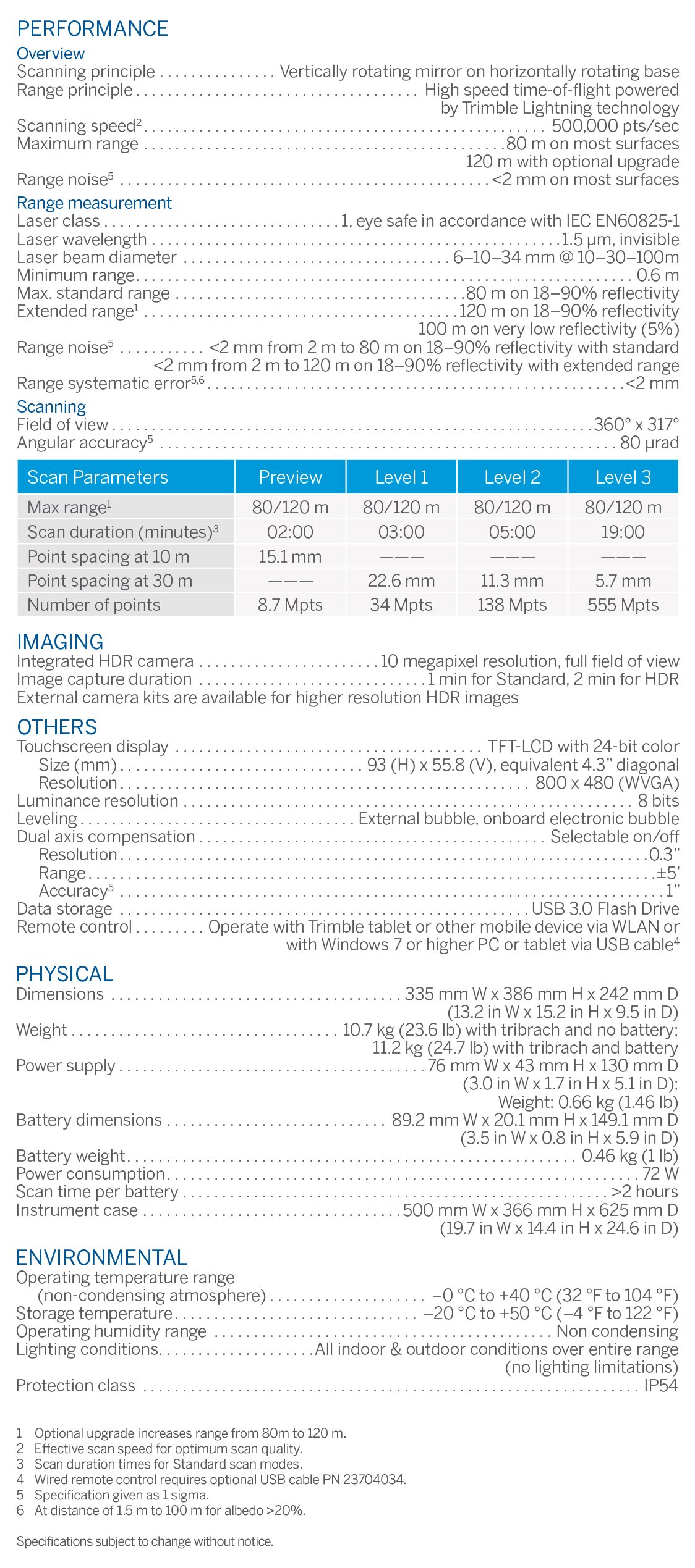
Trimble TX6 3D Laser Scanner (New) - Sale! (TX6)
Essential performance, range, accuracy and speed
$3,999.95 $5,714.21
Essential performance, range, accuracy and speed
500k pts/sec Scanning Speed
80m Standard, 120m Extended Scanning Range
Integrated HDR camera, 10 MP resolution Imaging
Essential performance – effective high speed scanning with consistent accuracy over the full scan range. The Trimble TX6 delivers superior performance compared to other similarly priced scanners
High quality data – quickly capture clean data even in bright sunlight. Be confident you will get the quality data you need with less setups to complete the project
Integrated HDR camera – Trimble VISION™ technology provides fast image capture to colorize scans with minimal impact on field productivity
Integrated WLAN – enables wireless remote operation from Windows, Apple and Android mobile devices.
Effective ranges – choose from standard 80 meter range or upgrade to extended 120 meter range to match the standard scan range of the Trimble TX8
Easy to operate – the intuitive onboard interface makes the TX6 easy to learn, reducing startup time. Users will immediately build confidence to successfully complete projects
Performance
500,000 points per second with no compromise on scan quality or range
Typical high density scan time of only 5 minutes
Integrated HDR camera to colorize scans
Easy to use onboard interface with no complex parameters
Integrated WLAN for remote operation from any mobile device
Robust design with IP 54 rating for demanding environments
Upgradeable from 80m standard to 120 meter extended range
Applications
Building Information Modeling (BIM)
Virtual Design Construction (VDC)
Pre-construction as-builts
Quality control
Preservation and restoration
Deformation monitoring
Plant and industrial measurement
Public safety and forensics
Software
The Trimble TX6 streamlines work in the office as well. The scanner’s clean, low-noise data reduces processing time. That data loads directly into Trimble RealWorks® software and Trimble Scan Explorer,enabling project collaboration via Internet Explorer. The Trimble TX6 paired with RealWorks also provides efficient data flow into popular CAD programs, Trimble EdgeWise and SketchUp® for point cloud modeling.

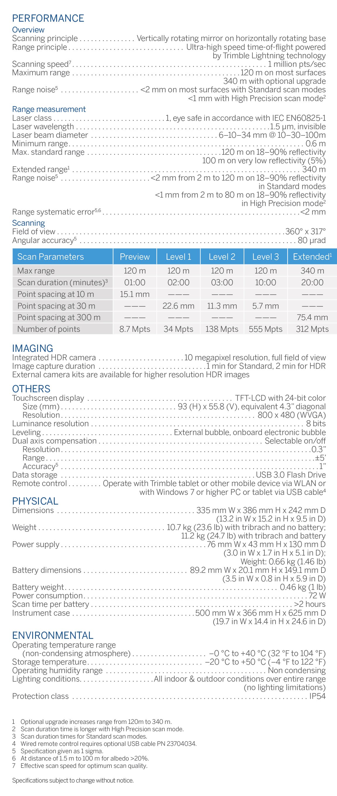
Trimble TX8 3D Laser Scanner (New) - Sale! (TX8)
Enables you to complete 3D laser scanning projects faster than ever
$4,655.35 $6,650.50
The Trimble® TX8 laser scanner sets new standards for performance and ease of use in high-speed collection of 3D data. Using a state-of-the-art blend of speed, long range and precision, the Trimble TX8 delivers high quality results in civil survey, industrial measurement, engineering and construction. It’s the scanner of choice for high levels of productivity, accuracy and flexibility.
Designed for performance, the Trimble TX8 enables you to complete 3D laser scanning projects faster than ever
- NEW – integrated HDR camera provides fast image capture to colorize scans with minimal impact on field productivity.
- NEW – integrated WLAN to enable wireless remote operation from Windows, Apple and Android mobile devices
- High end performance – ultra-high speed scanning with consistent accuracy over the full scan range. The Trimble TX8 delivers unsurpassed productivity in the field and office with fast, clean scans
- High quality data – quickly capture superior data even in bright sunlight. Be confident you will get the quality data you need with less setups to complete the project
- Long range – benefit from the extended range of 340 meters and gain the versatility to execute a wider range of projects. It’s like having two scanners in one
- Easy to operate – the intuitive on board interface makes the TX8 easy to learn, reducing startup time. Users will immediately build confidence to successfully complete projects
The Trimble TX8 is designed for a broad array of uses and environments.
Typical applications include:
► Civil engineering
► Surveying
► Plant and industrial measurement
► Mining and quarries
► Urban areas
► Preservation and restoration
► Building and commercial construction
► Deformation monitoring
► Quality control
► Public safety and forensics

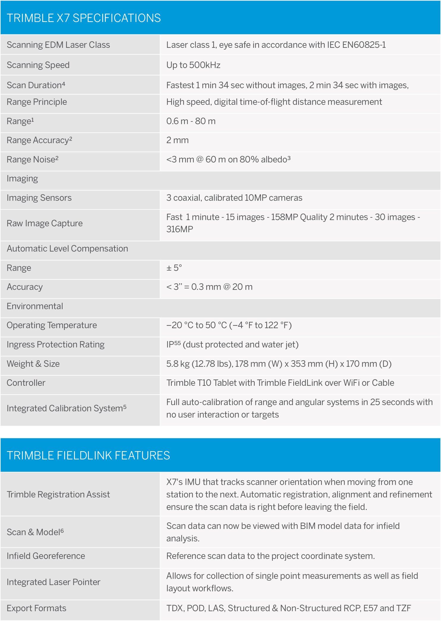
$4,365.13 $6,235.90
Construction-Ready 3D Laser Scanner
View scan data, 3D models and field layout points at the same time on a tablet controller while in the field.
Powerful Performance That is Easy to Use
Watch how simple it is to complete everyday scanning tasks using Trimble's X7 3D laser scanner powered by Trimble FieldLink.
Extend your BIM workflows and precisely capture accurate as-built conditions
Count on the X7 for guaranteed performance and accuracy so you can leave the site with total confidence in your data.
Increase Productivity
Manage your X7 with the same easy-to-use software as your layout process while also viewing scan data immediately in the field.
Reduce Downtime
Ensure data accuracy, eliminate downtime from annual calibration and provide a total lower overall cost of ownership.
Streamline Collaboration
Use Section View exports to send only the data you need to project stakeholders.
Powerful Performance with Simple Operation
Support a Variety of Tasks
No matter what you need to do, the X7 can do it. This includes: renovations, as-built verification, laser layout, precast set up verification, prefabrication skid QA/QC, post tension cable verification and more.
Full Visibility
View scan, model and layout data together in real-time to compare with actual field conditions.
Accurate Leveling Every Time
Automatic level detection ensures scans are level and provides the ability to scan upright or upside down.
Trimble Registration Assist
Increase your field productivity with full registration of the point cloud without any additional software.
Integrated Laser Pointer
Capture reference points to align scan data to the project coordinate system. Perform all your basic field layout tasks, from layout of field points to capturing measurements for QA/QC.
Automatic Calibration
Eliminate the need for annual calibrations – Reducing maintenance costs and downtime.

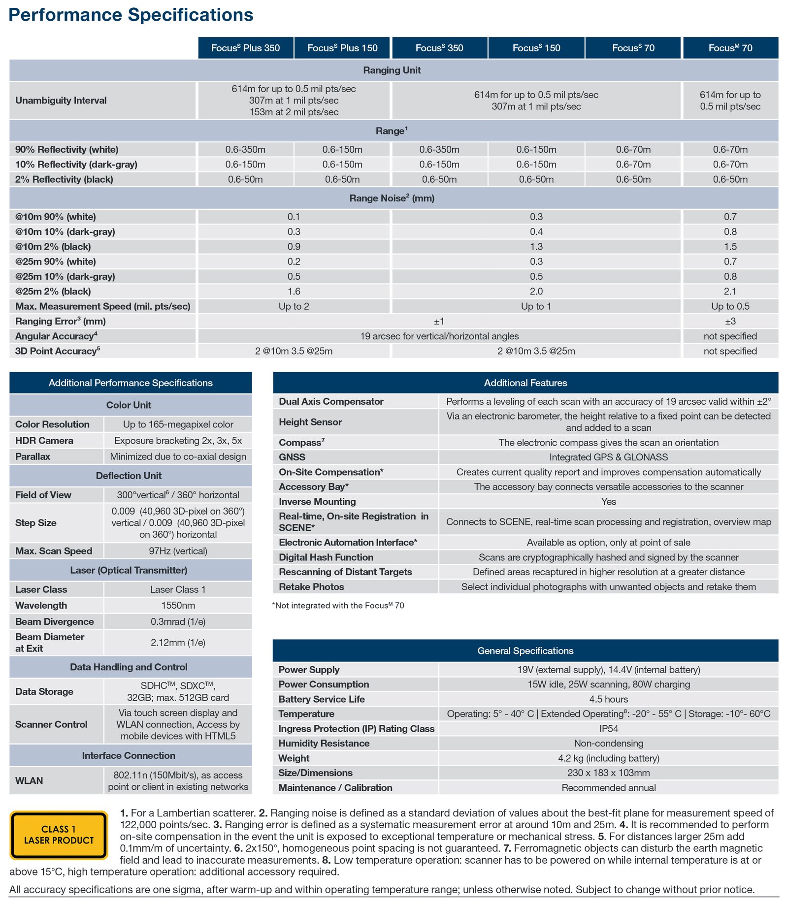
FARO Focus S70 Laser Scanner (New) - Sale! (Focus S70)
Highest accuracy and range by using a combination of the most advanced sensor technologies
$4,973.54 $7,105.05
Laser Scanners for Short, Medium and Long Range Applications
FARO® Focus Laser Scanners are specifically designed for both indoor and outdoor measurements in industries such as Architecture,
Engineering, Construction, Public Safety and Forensics or Product Design. All devices capture real world information used in the digital world to analyze, collaborate and execute decisions to improve and maintain the overall project and product quality.
The Focus S Laser Scanner series offers advanced functionality. In addition to increased distance, angular accuracy, and range, the Focus S and Focus S Plus scanners’ on-site compensation function ensures high-quality measurements, while external accessory bays and HDR functionality make the scanner extremely flexible.
Features:
Accuracy
Highest accuracy and range by using a combination of the most advanced sensor technologies.
Rescanning of Distant Targets
The Scan Group feature identifies multiple areas to be rescanned with higher resolution to either perform accurate target detection or to capture smaller areas of interest with greater detail.
IP Rating 54 and Extended Temperature Range
With the sealed design and certified with the industry standard Ingress Protection (IP) Rating, IP54, the Focus can be used in wet weather conditions at temperatures from -20°C to 55°C8.
Compact and Portable
Focus Laser Scanners are the smallest and lightest devices in their performance class.
On-Site Compensation
With the on-site compensation functionality, users can verify and adjust the Focus S compensation immediately before scanning, ensuring high-quality scan data and traceable documentation.
On-Site Registration
During on-site data capture, the laser scanner immediately transmits scan data wirelessly to FARO SCENE for real-time scan processing and registration, providing efficiency and time savings.
Benefits
• Confidence in documented data-quality by traceable calibration and market-leading on-site compensation.
• Scan in challenging environments while providing protection from dust, debris and water splashes. Mount the Focus S scanner in an inverted position, such as under a ceiling of a hall.
• The Focus Laser Scanner portfolio offers the most economic 3D scanning solution for all requirements and budgets.
• Minimum training effort is ensured by the intuitive and easy to operate touch-screen interface as well as hands-on and online tutorials.
• Efficient integration into existing software infrastructures and workflows are provided by interfaces to various standard CAD systems.

Trimble X7 3D Laser Scanner System (Used) - Sale! (X7)
With T10 Perspective and Accessories - Very good condition and tested working!
$3,563.18 $5,090.25
High-speed 3D laser scanning system with advanced technologies to simplify adoption, increase efficiency and provide confidence in the field powered by Trimble® Perspective.
Automatic Calibration: Complete confidence in every scan with the industry's first smart calibration system. No targets or user interaction required. On-Demand calibration reports
Self-leveling: Automatic survey grade level compensation
Trimble Registration Assist: Increase your field productivity with the industry's most comprehensive automatic registration
Laser Pointer: Provide visual confirmation of individual points to be measured by Trimble Perspective
Georeferencing: Link registered scans to a project coordinate system in Trimble Perspective
Applications
The Trimble X7 3D Laser Scanner is a compact, lightweight system with new innovations to simplify the adoption, increase efficiency and provide confidence in the field. With the Trimble X7 and Trimble Perspective field software, you get a dependable instrument backed by an industry-leading two-year warranty and comprehensive workflows to validate scan projects in the field.
Building Construction/Facility Management
Industrial Survey
Civil Infrastructure
Topographic/General Surveys
Road Intersection Surveys
Forensics
Utilities
Marine Construction
Tank Calibration & Inspection
Mining
Cultural Heritage
Software
Scanner Operation: Remote control or cable
Trimble Registration Assist: Automatic and manual registration, refinement, and reporting.
Data Interaction: 2D, 3D, and Station View
In-field Documentation: Scan labels, annotations, pictures, and measurements
Auto Sync: Automatic data sync from the one-button operation
Data Redundancy: Data stored on SD Card and tablet
Data Integration: Export formats to support Trimble and non-Trimble software
File formats: TDX, TZF, E57, PTX, RCP, LAS, POD
INCLUDED:
T10 tablet
Series 3 tripod
quick release,
backpack
Trimble X7 Scanner
Perspective software
1-year warranty
Batteries/Chargers

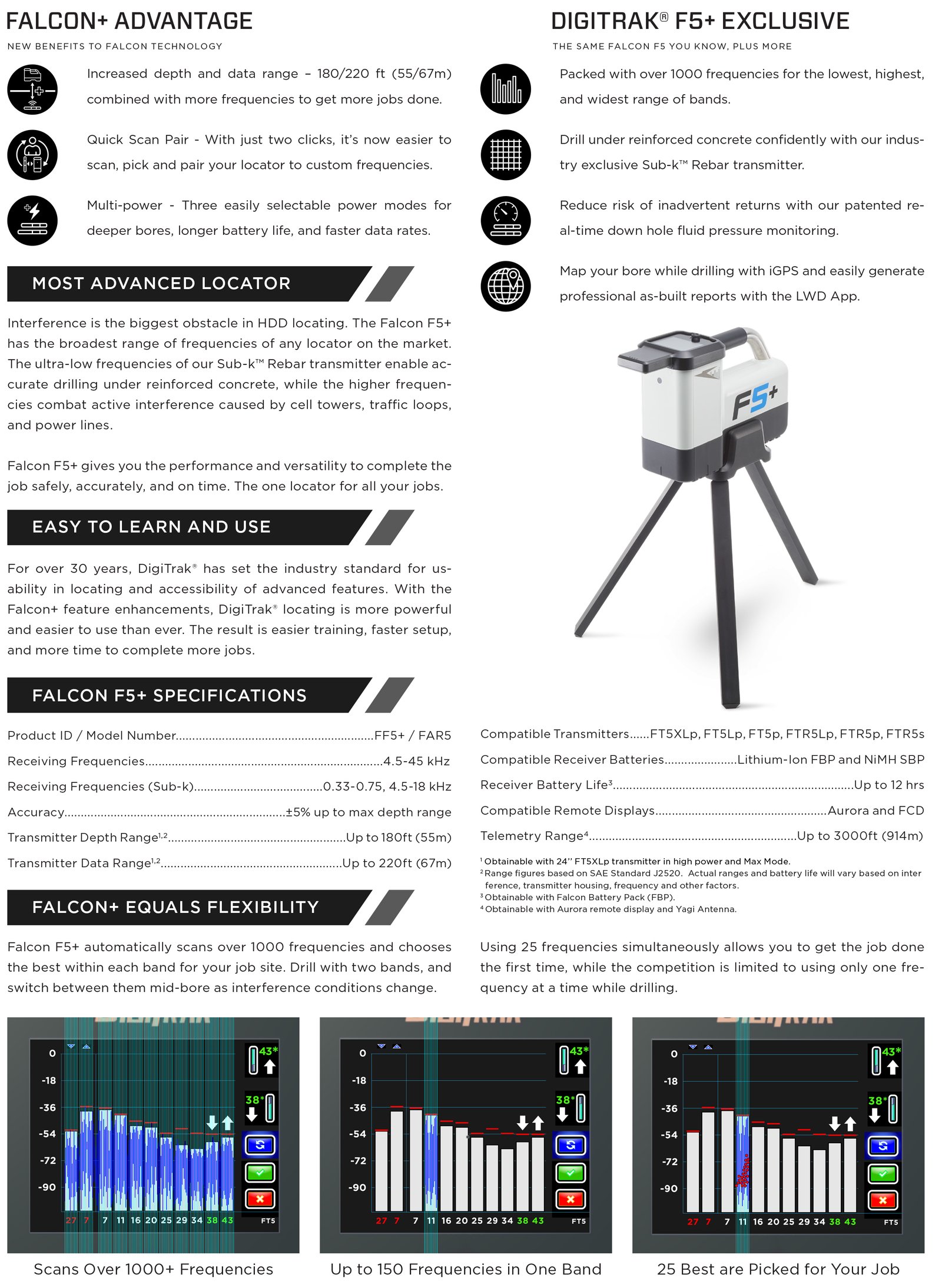
Digitrak Falcon F5 Plus Locator System (New) - Sale! (Falcon F5 Plus)
Has the broadest range of frequencies of any locator on the market
$4,889.57 $6,918.88
Digitrak Falcon F5 Plus Locator System
DigiTrak Falcon F5 gives you the performance and versatility to complete the job safely, accurately, and on time.
The One Locator For All Your Jobs
Falcon F5 automatically scans over 1000 frequencies and chooses the best within each band for your job site. Drill with two bands, and switch between them mid-bore as interference conditions change.
FEATURES:
Depth & Data
Increased depth and data range – 180/220 ft (55/67m) combined with more frequencies to get more jobs done.
Quick Scan Pair
Quick Scan Pair – With just two clicks, it’s now easier to scan, pick and pair your locator to custom frequencies.
Multi-Power
Three easily selectable power modes for deeper bores, longer battery life, and faster data rates.
Falcon Technology
Packed with over 1000 frequencies for the lowest, highest, and widest range of bands.
Rebar Transmitters
Drill under reinforced concrete confidently with our industry-exclusive Sub-k® Rebar transmitter.
Fluid Pressure
Reduce risk of inadvertent returns with our patented real-time down hole fluid pressure monitoring.

MALA Easy Locator Pro WideRange HDR (New) - Sale! (Easy Locator Pro)
The professional’s choice for utility mapping
$5,175.83 $6,901.10
The professional’s choice for utility mapping. MALÅ Easy Locator Pro (EL Pro) is a cost-effective GPR solution that provides a comprehensive, end-to-end choice for utility mapping. It is the third generation of the EL-series.
Buried utilities are assets that need protection, so it is vital to gather precise and reliable information about the location and depth of buried infrastructure. MALÅ EL Pro offers the most comprehensive, non-destructive solutions for obtaining subsurface information about metallic and non-metallic utilities.
Based on real-time sampling technology, MALÅ EL Pro is faster, offers higher data resolution and significantly better penetration depth compared to traditional GPR technology. It can export 32 bit HDR data to stand-alone software and the solution is supplied with MALÅ Object Mapper and GPS Mapper software.
With its unique level of data precision and data resolution, MALÅ EL Pro is the professional choice for utility mapping.
Features & Advantages
- Outstanding data quality
- Easy-to-use, foldable all-in-one unit
- Fast data acquisition
- Built-in DGPS for improved positioning
- Data export and post-processing software
- Exceptional detection capabilities
Technical Specifications – EL Pro Controller
- Processor: 1.6 GHz Intel Atom
- Display: 1024 x 768
- Memory: 8 GB compact Flash memory
- Data output resolution: 32 bit
- Comms: Ethernet, USB 2.0, RS232 (serial)
- GPS: Integrated support for built-in GPS, or external GPS via USB/serial port (NMEA 0183 protocol)
- Power supply: Any external 10-15 V DC source.
- Charger: Internal charger. Unit can also be charged from any external 12 – 15 V DC source.
- Power consumption: 3 – 2.0 A
- Operating time: 8 – 14 h (depending on number of external batteries)
- Dimensions: 430 x 360 x 180, including handles
- Weight: 5 kg
- Operating temp: -20 °C to 50 °C or 0 °F to 120 °F
- Environmental: IP65
Technical Specifications – EL Pro Antenna
- Technology: MALÅ Semi-Real-Time pat pending
- Antenna center freq.: 450 MHz
- SNR: > – 101 dB
- Significant/useful number of bits: > 16 bit
- Scans/second: > 770, time window 300 nS
- Survey speed: 275 [km/h] point distance 10 cm
- Time window: 300 ns
- Operating time: 5 h
- Bandwidth: >120 %, fractional, -10 dB
- Positioning: Built-in DGPS, external GPS, wheel encoder
- Power supply: Interchangeable 12 V Li-Ion battery or ext. 12 V DC source
- Power consumption: 3 A
- Mode: Wheel, time or manual
- Dimensions: 430 x 360 x 180 mm
- Weight: 5 kg
- Operating temp: -20 °C to 50 °C or 0 °F to 120 °F
- Environmental: IP65
Technical Specifications – EL Pro Cart
- Dimensions: (folded for transport) 820 x 560 x 400 (L x W x H)
- Dimensions: (when in use) 1100 x 560 x 1000 (L x W x H)
- Weight: 13 kg
- Battery bay/compartment: Fits four 12 V Li-Ion
Package Included:
21-005860 – Easy Locator Pro Widerange HDR
21-005332 – EL Pro Widerange Controller
21-005005 – Battery adapter for HDR Shielded Antennas
21-005002 – GPS tower for Shielded Antennas HDR
21-004004A- Li-Ion Battery pack 12V
21-002648 – Li-ion Battery Charger 12.6 V
21-005865 – ProCart Widerange
18-005000 – Easy Locator HDR Screen Capture & DGPS option
19-001050 – MALA USB Software and Manuals Package
Accessories
- Rough Terrain Cart (RTC)
- Extra battery options

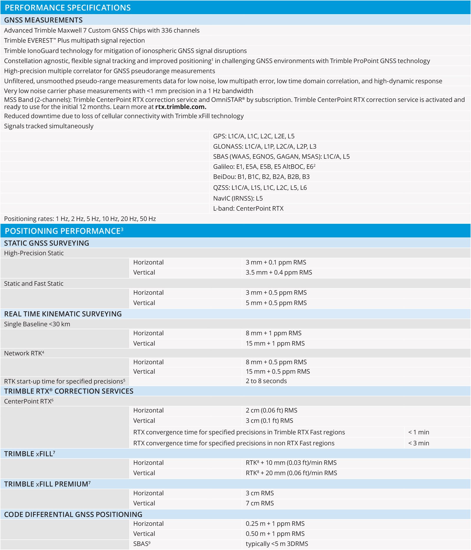
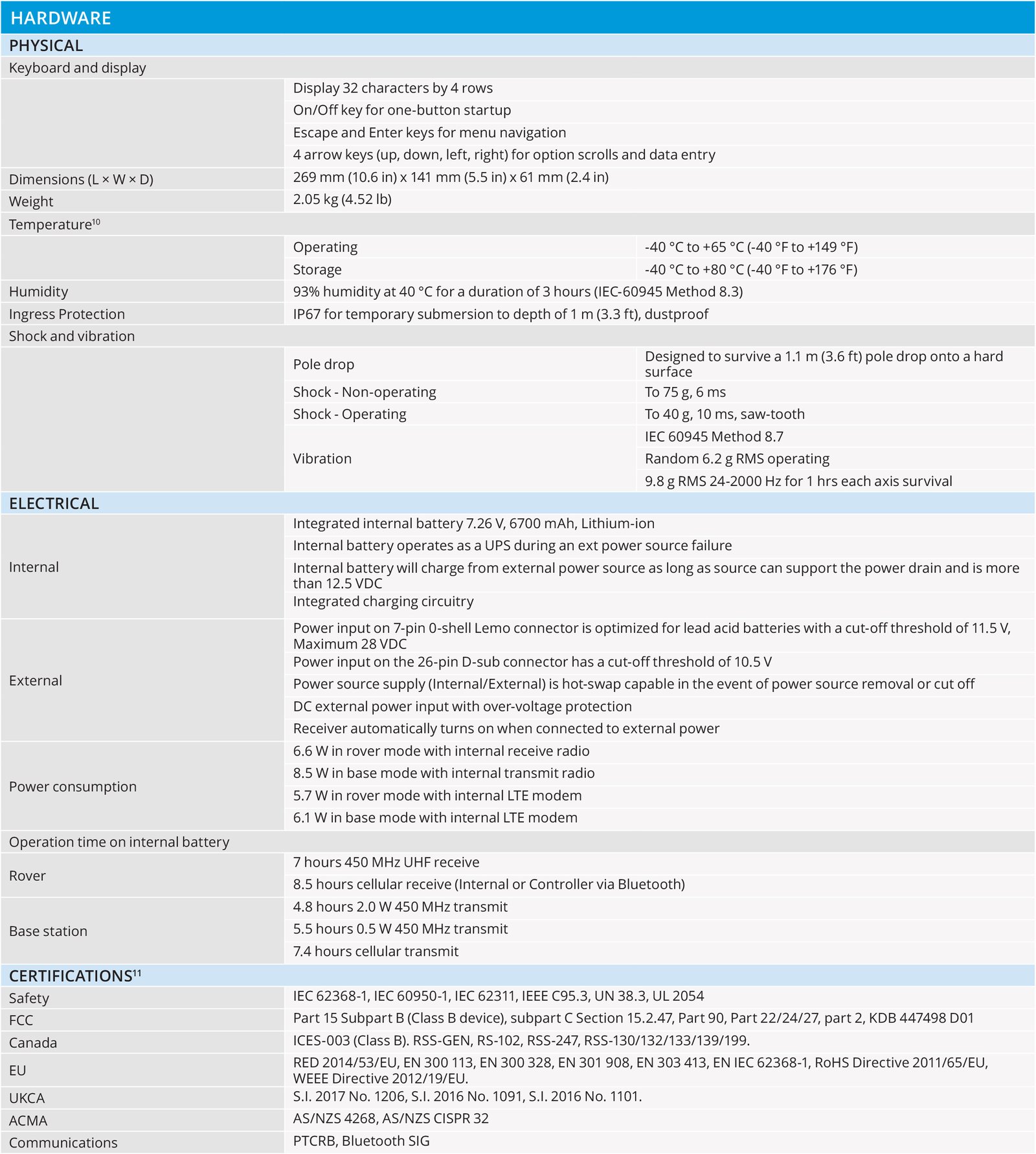
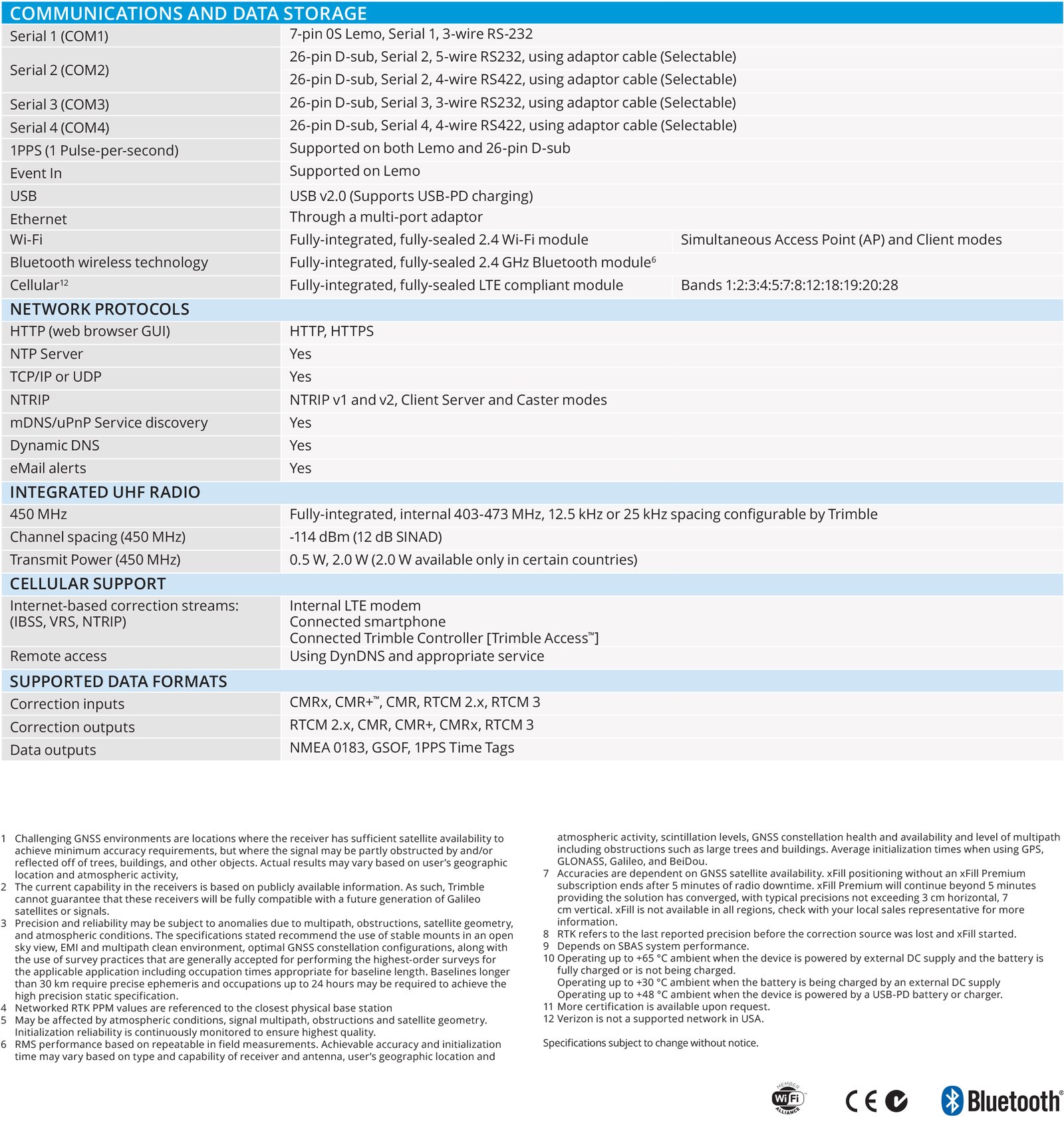
Trimble R750 Modular GNSS Receiver (New) - Sale! (R750)
Work efficiently and accurately, even in tough conditions
$1,577.95 $2,103.93
Work with global precision.
Get reliable coverage no matter where you work with the Trimble® R750 modular GNSS receiver. Work efficiently and accurately, even in tough conditions, while receiving all the information you need, right at your fingertips.
Key specifications
Transform your surveying work. Get precise results every time with industry-leading positioning, including from Trimble ProPoint® GNSS technology.
8 mm H/15 mm V : Real-time kinematic precision
4G LTE : Integrated worldwide modem
450 MHz : Integrated 2 Watt UHF transceiver
Features and capabilities
EASILY UPGRADE
Access scalable features
Choose the features you need to get the job done with the R750. Enjoy the flexibility to upgrade effortlessly when facing new challenges in the future.
TRUSTED TRACKING
Future-proof GNSS tracking
Experience the ultimate in GNSS tracking with Trimble Maxwell™ 7 GNSS ASIC. Track the latest signals from all GNSS constellations for unparalleled accuracy.
UNLOCK GLOBAL PRECISION
Bring precision anywhere
Achieve RTK-level precision with Trimble CenterPoint RTX™ corrections without relying on a local base station or VRS network, giving you the freedom to work anywhere.
BOOST PRODUCTIVITY
Navigate with confidence
With Trimble ProPoint, improve your rover's capabilities with a powerful, robust positioning engine that boosts reliability and productivity.
Industries and applications
The future of your work.
Trimble facilitates high quality, productive workflows and data exchange, driving value for a global, diverse user base.
Industries
Discover how Trimble can help you solve your industry's most complex challenges and uncover opportunities to work smarter.
Applications
Trimble transforms data into real-world intelligence using the most progressive, reliable and accurate precision technology to meet needs of varied applications.

$3,616.78 $4,578.20
Overview
Scanning principle: Vertically rotating mirror on horizontally rotating base
Range principle: Ultra-high speed time-of-flight powered by Trimble Lightning technology
Scanning speed: 1 million pts/sec
Maximum range: 120 m on most surfaces 340 m with optional upgrade
Range noise: <2 mm on most surfaces with Standard scan modes <1 mm with High Precision scan mode2
Range measurement
Laser class: 1, eye safe in accordance with IEC EN60825-1
Laser wavelength: 1.5 µm, invisible
Laser beam diameter: 6–10–34 mm @ 10–30–100m
Minimum range: 0.6 m
Max. standard range: 120 m on 18–90% reflectivity 100 m on very low reflectivity (5%)
Extended range1: 340 m
Range noise: <2 mm from 2 m to 120 m on 18–90% reflectivity in Standard modes; <1 mm from 2 m to 80 m on 18–90% reflectivity in High Precision mode
Range systematic error: <2 mm
Scanning
Field of view: 360° x 317°
Angular accuracy: 80 µrad
Imaging
Integrated HDR camera: 10 megapixel resolution, full field of view
Image capture duration: 1 min for Standard, 2 min for HDR, External camera kits are available for higher resolution HDR images
Others
Touchscreen display: TFT-LCD with 24-bit color
Size (mm): 93 (H) x 55.8 (V), equivalent 4.3” diagonal
Resolution: 800 x 480 (WVGA)
Luminance resolution: 8 bits
Leveling: External bubble, onboard electronic bubble
Dual axis compensation: Selectable on/off
Resolution: 0.3”
Range: ±5’
Accuracy: 1”
Data storage: USB 3.0 Flash Drive
Remote control: Operate with Trimble tablet or other mobile device via WLAN or with Windows 7 or higher PC or tablet via USB cable4
Physical
Dimensions: 335 mm W x 386 mm H x 242 mm D (13.2 in W x 15.2 in H x 9.5 in D)
Weight: 10.7 kg (23.6 lb) with tribrach and no battery; 11.2 kg (24.7 lb) with tribrach and battery
Power supply: 76 mm W x 43 mm H x 130 mm D (3.0 in W x 1.7 in H x 5.1 in D);
Weight: 0.66 kg (1.46 lb)
Battery dimensions: 89.2 mm W x 20.1 mm H x 149.1 mm D (3.5 in W x 0.8 in H x 5.9 in D)
Battery weight: 0.46 kg (1 lb)
Power consumption: 72 W
Scan time per battery: >2 hours
Instrument case: 500 mm W x 366 mm H x 625 mm D (19.7 in W x 14.4 in H x 24.6 in D)
Enviromental
Operating temperature range (non-condensing atmosphere): –0 °C to 40 °C (32 °F to 104 °F)
Storage temperature: –20 °C to 50 °C (–4 °F to 122 °F)
Operating humidity range: Non condensing
Lighting conditions: All indoor & outdoor conditions over entire range (no lighting limitations)
Protection class: IP54
Includes;
Trimble TX8 (HDR Camera & WLAN)
Trimble Realworks Advanced License
Trimble TX Battery Kit, including charger, 4 batteries, cables, and hard case
Power Supply 12V & Power Cable & Adapters
Tribrach with Optical Plummet
Tri-Max Universal Elevator Tripod
USB 3.0 Flash Drive 64GB
Trimble Stylus Lanyard
Solid GG Stylus, 1 Tether Packout Assy
Pack x10 Adhesive B&W Checker Target
Pack x2 screen protector 91.8 x 54.5mm
Lens Cleaning Cloth
Transportation case
Trimble TX8 Started Guide
2 Year Trimble Warranty

Trimble TX6 3D Laser Scanner (Used) - Sale! (TX6 3D)
Easy to use onboard interface with no complex parameters - Very good condition and tested working!
$3,539.36 $4,480.20
Features
- Essential performance – effective high speed scanning with consistent accuracy over the full scan range. The Trimble TX6 delivers superior performance compared to other similarly priced scanners
- High quality data – quickly capture clean data even in bright sunlight. Be confident you will get the quality data you need with less setups to complete the project
Integrated HDR camera – Trimble VISION technology provides fast image capture to colorize scans with minimal impact on field productivity
- Integrated WLAN – enables wireless remote operation from Windows, Apple and Android mobile devices.
- Effective ranges – choose from standard 80 meter range or upgrade to extended 120 meter range to match the standard scan range of the Trimble TX8
- Easy to operate – the intuitive onboard interface makes the TX6 easy to learn, reducing startup time. Users will immediately build confidence to successfully complete projects
Performance
500,000 points per second with no compromise on scan quality or range
Typical high density scan time of only 5 minutes
Integrated HDR camera to colorize scans
Easy to use onboard interface with no complex parameters
Integrated WLAN for remote operation from any mobile device
Robust design with IP 54 rating for demanding environments
Upgradeable from 80m standard to 120 meter extended range
Applications
Building Information Modeling (BIM)
Virtual Design Construction (VDC)
Pre-construction as-builts
Quality control
Preservation and restoration
Deformation monitoring
Plant and industrial measurement
Public safety and forensics
Includes:
1 Trimble TX6 3D laser scanner with HDR, Wi-Fi
4 Trimble TX6 batteries
1Trimble TX6 batteries charger with power supply
1 USB flash drive for storing data
1 Trimble TX6 quick start guid, qty 1
1 Trimble yellow transport case for TX6

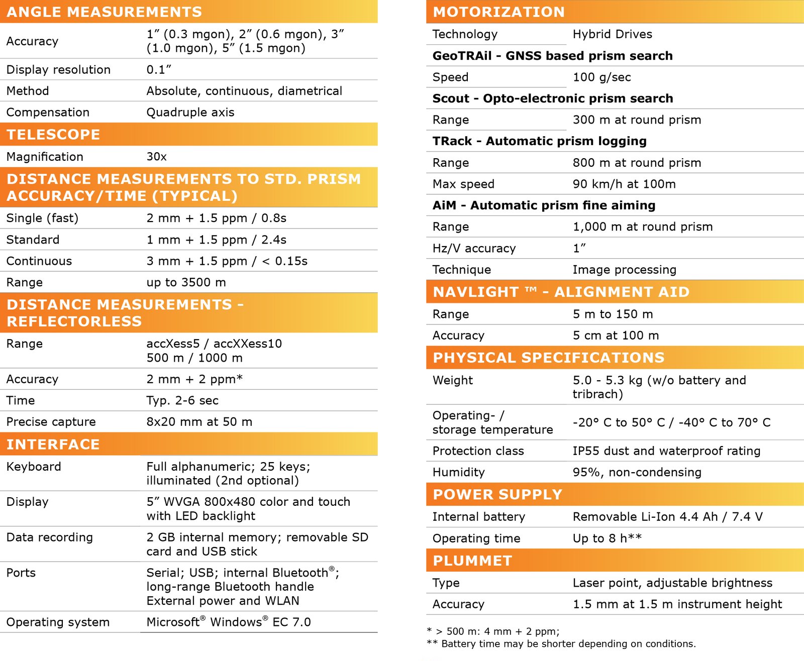
GeoMax Zoom95 Robotic Total Station (New) - Sale! (Zoom95)
The true flagship of the GeoMax TPS portfolio
$4,748.42 $5,935.53
The Zoom95 is the true flagship of the GeoMax TPS portfolio. Featuring advanced STReAM360 technology, this one-person total station substantially minimizes the time of any survey task and maximizes your performance and accuracy. Combined with the X-PAD field software, the user-friendly and flexible solution makes it easy to start digitizing your construction site.
Modern Data capturing & handling
No more paper plans. Upload your plans onto the X-PAD Ultimate field software or into the TPS, and conveniently edit the CAD drawings on-site on the big screen of the GeoMax robotic total stations. Big files can be handled easily and fast thanks to the strong performing processor of the Zoom95. With the unique X-TILT feature and the Zenius800, inaccessible points are no longer a challenge. X-TILT automatically calculates a point position by tilting the tablet attached to the prism pole, in two directions.
Seamless workflow with maximum flexibility
X-PAD software, GeoMax field controllers and the Zoom95 robotic TPS are carefully chosen and developed to enable a carefree and efficient workflow. X-PAD gives you the flexibility to choose your preferred operating system and field controller as it is available as fully-featured Android ™ and Windows ® field software running on a multitude of field controllers.
Fully Robotic
With the STReAM360 technology, the Zoom95 easily and quickly finds, locks and traces the prism:
- Scout: Vertical laser fan is emitted from the rotating instrument. As soon as reflections from a prism are received, the Zoom95 accurately aims towards this prism.
- TRack: The target is being continuously tracked. Once locked onto, the instrument remains accurately aimed even on fast moving targets.
- AiM: The Zoom95 aims accurately at any prism, without the need to look through the telescope.
Convenient and safe data management
X-PAD 365, the web-based GeoMax cloud platform, was created to address data management and collaboration challenges surveyors and construction professionals meet every day. Working with the Zoom95, data can be accessed, stored, and shared via the X-PAD 365 File Manager. Your data is always safe, thanks to automatic backups. Furthermore, the Collaborative Survey and Stakeout feature allows several users to work on the same surveying or stakeout project together, sharing real-time surveyed points and drawings and immediately seeing their progress.
Keep X-PAD at its best - select your service
X-PAD Ultimate software is always maintained without any extra costs. By keeping your X-PERT service active, you can continuously profit from the latest software improvements.
Reliable partner
Hexagon is known for driving innovation and technological progress. As a part of this group, GeoMax can guarantee that its solutions work when you do.

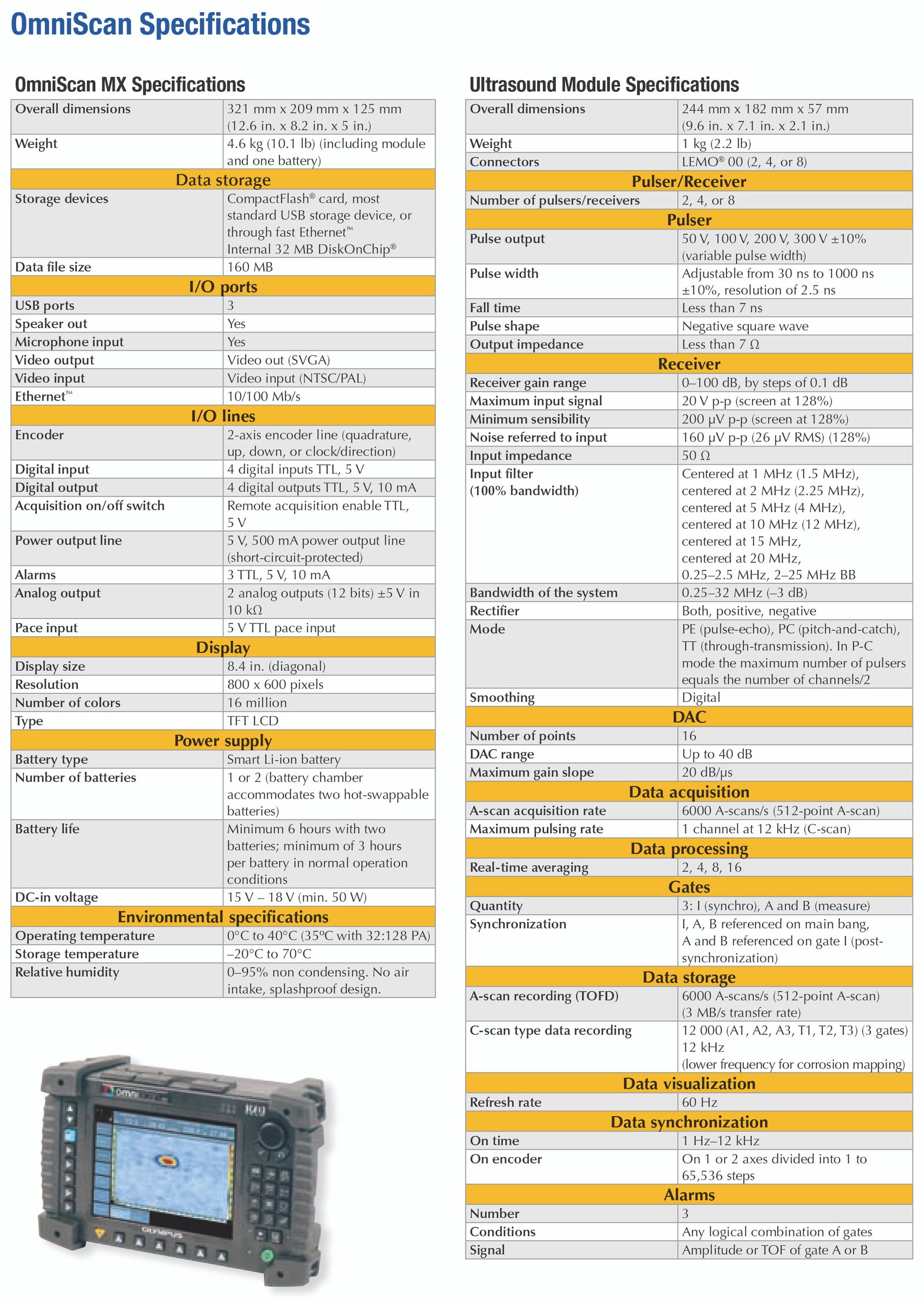
Olympus OmniScan MX 16:128 Phased Array Flaw Detector (New) - Sale! (OmniScan MX)
Rugged, Portable, and Battery-Operated
$3,929.76 $4,912.20
With hundreds of units used throughout the world, the R/D Tech OmniScan MX is Olympus NDT’s most successful modular and portable phased array and eddy current array test unit. The OmniScan family includes the innovative phased array and eddy current array test units, as well as the eddy current and conventional ultrasound modules, all designed to meet the most demanding requirements of NDT. The OmniScan MX offers a high acquisition rate and powerful software features in a portable, modular mainframe to efficiently perform manual and automated inspections.
Rugged, Portable, and Battery-Operated
The OmniScan is built to work in the harshest field conditions. Its solid polycarbonatebased casing and rubber bumpers make it a rugged instrument that can withstand drops and shocks.
The OmniScan is so compact and lightweight (only 4.6 kg) that it can be carried easily and handled anywhere inside or outside. The OmniScan will run 6 hours with its two Li-ion batteries.
User Interface
The highly legible 8.4-inch real-time display (60-Hz A-scan refresh rate) with a SVGA resolution of 800 x 600 allows you to clearly see defects and details under any light conditions. A scroll knob and function keys make it easy to browse through and select functions. A mouse and a keyboard can also be plugged in for users looking for a more PC-like interface.
Modular Platform
The instrument is a modular platform that allows you to switch among its different test modules on location. The platform detects the new module and the technology supported so that the configuration and test environment are set automatically.
OmniScan Connector
The OmniScan connector has a probe ID feature that enables physical detection and recognition of the probe connected to the mainframe.
- Sets the probe to an appropriate frequency to prevent probe damage
- Sets C-scan resolution of ECA probes
- Loads the correct probe parameters
Typical Applications
Girth Weld Inspection
Olympus NDT has developed a circumferential weld inspection system based on the OmniScan PA for the oil and gas industry. This phased array system is qualified to inspect tube with diameters ranging from 48 mm to 1524 mm and thicknesses from 5 mm to 25 mm in compliance with ASME Boiler and Pressure Vessel Code Section V. The semiautomated system offers better inspection speed and detection, and makes the interpretation of the indications significantly easier.
Pressure Vessel Weld Inspection
The combination of time-of-flight diffraction (TOFD) and pulse-echo techniques means that the complete inspection is done in a single scan, significantly reducing the inspection time when compared to conventional raster scanning or radiography. Inspection results are available instantaneously, allowing you to spot a problem with the welding equipment and fix it right away. Based on our vast experience in the nuclear and petrochemical industries, this system includes all the functions that are needed for code-compliant weld inspections.
Scribe Marks Inspection with No Paint Removal
The Flight Standards Information Bulletin for Airworthiness (FSAW 03-10B), issued on November 2003, report damage along fuselage skin lap joints, butt joints, and other areas of several aircraft caused by the use of sharp tools used during paint and sealant removal.
The OmniScan allows the scribe marks inspection to be done without paint removal which is a huge time saver. The inspection is done in a single pass using 60º to 85º SW sector scans. OmniScan PA is now referenced in the Boeing NTM manuals, 737 NDT Manual, Part 4, 53-30-06, July 2005.
Aircraft Fuselage Inspection
The OmniScan ECA (eddy current array) provides the ability to detect hidden corrosion and cracks in multilayer structures. Currently, material loss of 10% of the lap splice thickness can be detected in aluminum at a depth of 0.2 in. Surface and subsurface cracks can be detected in the skin, at the fastener, or at the lap joint edges.
Ultrasound Inspection
Time-of-Flight Diffraction (TOFD) Testing
TOFD is a technique that uses two probes in pitch-and-catch mode. TOFD detects and records signals diffracted from defect tips for both detection and sizing. The TOFD data is displayed in a grayscale B-scan view. TOFD offers wide coverage and amplitudeindependent sizing compliant with the ASME-2235 code.
- One-line scan for full-volume inspection
- Setup independent of weld configuration
- Very sensitive to all kinds of defects and unaffected by defect orientation
Time-of-Flight Diffraction (TOFD) and Pulse-Echo Testing
While TOFD is a very powerful and efficient technique, it suffers from limited coverage resulting from two dead inspection zones: one dead zone is near the surface, the other is at the backwall.
OmniScan UT allows inspections simultaneously combining TOFD with conventional pulse echo. Pulse echo complements TOFD and covers the dead zones.
- TOFD inspection
- 45º pulse-echo for weld cap inspection on either sides of the weld
- 60º pulse-echo for weld root inspection on either sides of the weld
0-Degree Testing (Corrosion and Composite)
The 0-degree testing measures time-offlight and amplitude of ultrasonic echoes reflecting from the part into gates in order to detect and measure defects.
- C-scan imaging
- Full A-scan recording with C-scan postprocessing
Ultrasound Transducers
Olympus NDT offers thousands of transducers in standard frequencies, element diameters, and connector styles.
- Contact and immersion transducers
- Dual transducers
- Angle beam transducers and wedges
- Replaceable delay line transducers
- Protected-face transducers
- Normal incidence shear wave transducers
Phased Array Inspection
Phased Array Technology
Phased array technology generates an ultrasonic beam with the capability of setting beam parameters such as angle, focal distance, and focal point size through software. Furthermore, this beam can be multiplexed over a large array. These capabilities open a series of new possibilities. For instance, it is possible to quickly vary the angle of the beam to scan a part without moving the probe itself. Phased arrays also allow the replacement of multiple probes and even mechanical components. Inspecting a part with a variable-angle beam also maximizes detection regardless of the defect orientation, while optimizing signalto-noise ratio.
Benefits of Phased Arrays
Phased array technology offers the following capabilities:
- Software control of beam angle, focal distance, and spot size
- Multiple-angle inspection with a single, small, electronically-controlled multielement probe
- Greater flexibility for the inspection of complex geometry
- High-speed scans with no moving parts
Eddy Current Inspection
Eddy Current Technology
Eddy current (ECT) technology is a noncontact method for the inspection of metallic parts. In this technique, the probe, which is excited with an alternating current, induces eddy current in the part being inspected. Any discontinuities or material property variations that change the eddy current flow in the part are detected by the probe as a potential defect.
Over the years, probe technology and data processing have continuously progressed so that the eddy current technique is now recognized to be fast, simple, and accurate. This is why the technique is widely used in the aerospace, automotive, petrochemical, and power generation industries for the detection of surface or near-surface defects in material such as aluminum, stainless steel, copper, titanium, brass, Inconel®, and even carbon steel (surface defect only).
Benefits of Eddy Current
Eddy current offers the following capabilities:
- A quick, simple, and reliable inspection technique to detect surface and near-surface defects on conductive material
- Can be used to measure electrical conductivity of the material.
- Measurement of nonconductive coating
- Hole inspection with the use of highspeed rotating scanner and surface probe
Eddy Current Probes
Olympus NDT standard eddy current probes are available in different configurations:
- Bolt hole probes
- Surface probes, in various shapes and configurations
- Low-frequency Spot and Ring probes
- Sliding probes
- Wheel probes
- Conductivity probes
- Speciality probes made for specific applications

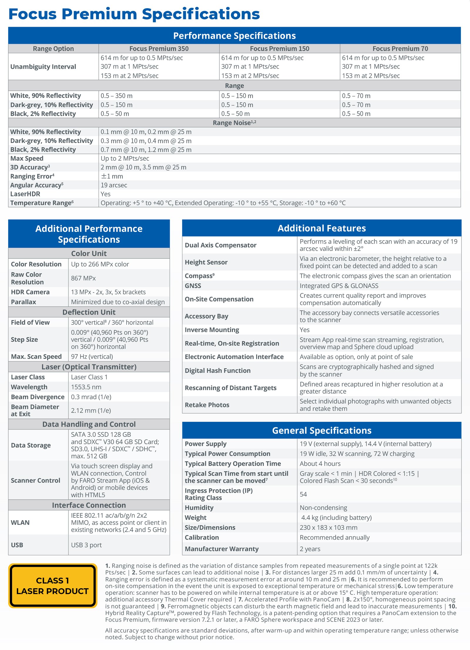
FARO Focus Premium 150 Laser Scanner (New) - Sale! (Focus Premium 150)
Super-High Color Resolution
$5,830.12 $7,109.90
FARO Focus Premium Laser Scanner, Up to 50% faster scan times, Super-High Color Resolution
Capturing the measurements of a large building, facility, or crash/crime scene with conventional documentation methods can take days or weeks, and even then, the data might contain errors or missing details. But FARO Focus Premium creates accurate, complete and photorealistic 3D representations of any environment or object in just a few minutes. Focus Premium is easy to operate and offers built-in protection from dirt, dust, fog, rain and heat/ cold.
And, for best on-site data capture, Focus Premium connects with the new FARO Stream app, bridging FARO hardware to the FARO Sphere cloud environment. Pre-registration scans are fed directly into the cloud, so jobs can be done more efficiently — feedback is captured and processed as you work.
FARO Premium Scanner Features:
Up to 50% faster scan times
About 1 minute to complete a typical scan, in combination with the optional FARO PanoCam upgrade, even in colour.
Super-High Colour Resolution
The latest colour technology enables the Focus Premium to capture scans with up to 266 megapixel colour information.
Two-Year warranty
Competitive service means maximizing the life of this product while reducing the total cost of ownership throughout the device’s lifespan. Two years allows for maximum flexibility and the piece of mind knowing that any repairs or defective parts will be replaced.
Software Compatibility
Process your Focus Laser Scanner point cloud data with any software tool that fits your workflow, including FARO software solutions and third-party software such as Autodesk® ReCap™.
Multiple Point Clouds, Multiple Devices
The new Focus is also designed to work seamlessly with the FARO Freestyle 2 Handheld Scanner, thanks to its “Snap-In” feature. Save the time that is required for multiple scanner positions when it comes to scanning complex environments/structures, equipment or tight spaces. Snap-in enables the user to seamlessly add data starting from a Focus point cloud by using it as a reference for missing data from such hard-to-scan locations, including areas in shadow and objects with irregular geometries.
The FARO Focus Premium come with the following items;
Faro Focus Premium Laser scanner
Power dock battery charger
Power supply unit
Power block battery (ACCS-PWR-0014)
Scanner transport and carrying case
Mirror cleaning liquid for optics
SD card reader (An SD card is already inserted in the scanner.)
Status indicator
4mm hex key
Quick release
Quick Start Guide and Safety Manual
AC power cable