

 - Sale!")
 - Sale!")
 - Sale!")
 - Sale!")
 - Sale!")


GeoSLAM ZEB Horizon RT Mobile Scanner (New) - Sale!
GeoSlam
A mobile LiDAR scanner with high versatility
£3,990.19
£4,534.30
A mobile LiDAR scanner with high versatility, ZEB Horizon RT is the ideal solution for a variety of workflows including both outdoor and indoor mapping. Ideal for geospatial surveying including construction, mining or forestry, the compact design offers one tool for many solutions. The real-time feedback feature ensures users capture all the data they need while on-site, resulting in cost savings and faster job turnarounds.
Powered by GeoSLAM’s proprietary and ever-evolving SLAM algorithm, the ZEB Horizon RT is the ideal solution for surveying professionals looking for faster deliverables and higher efficiency, with the ability to scan handheld or via drone, car mount, cradle, pole, or backpack.
Business Value of GeoSLAM ZEB Horizon RT
Transition Through Environments
Seamlessly transition through an area, capturing entire datasets in one go. From interior to exterior, or stairwell to corridor, walking and mapping are made easier with mobile LiDAR solutions like the ZEB Horizon RT.
Map Hard to Reach Areas
Better understand spaces by capturing hard-to-reach sections of an area. The versatility of the ZEB Horizon RT provides opportunities to lower a scanner into vent shafts or elevate it into ceiling voids, increasing user safety.
Capture Data Faster
The lightweight nature of the scanner unlocks the potential for faster data capture. There isn’t a requirement for multiple setups to provide a desired outcome. Users simply need to switch on the scanner, walk and scan simultaneously, and return to their beginning point.
Repeat Scans as Often as Needed
The ease of use leads to anybody being able to map an area quickly with the mobile scanner. The process is repeatable as often as every day, if needed, leading to frequent and up-to-date data for all stakeholders, for more informed and faster decision-making.
It’s Not Just About Data Capture
Data capture is just one component of many workflows. What happens to that data and how information is extracted is equally, if not more, important. A solid software platform, like FARO Connect, provides the means to process data quickly and offers an array of automated pre-built workflows – such as change detection — allowing users to make the most of the data they collect.
Take Your Data Further
Following initial processing and analysis, point cloud data can be taken into a range of third-party software to make further enhancements and complement existing workflows.
Complement Other Forms of Data Capture
Combining SLAM systems with other LiDAR solutions, like the FARO Focus, offers a complete data capture package for an accurate, fast, and repeatable way to obtain point cloud data.
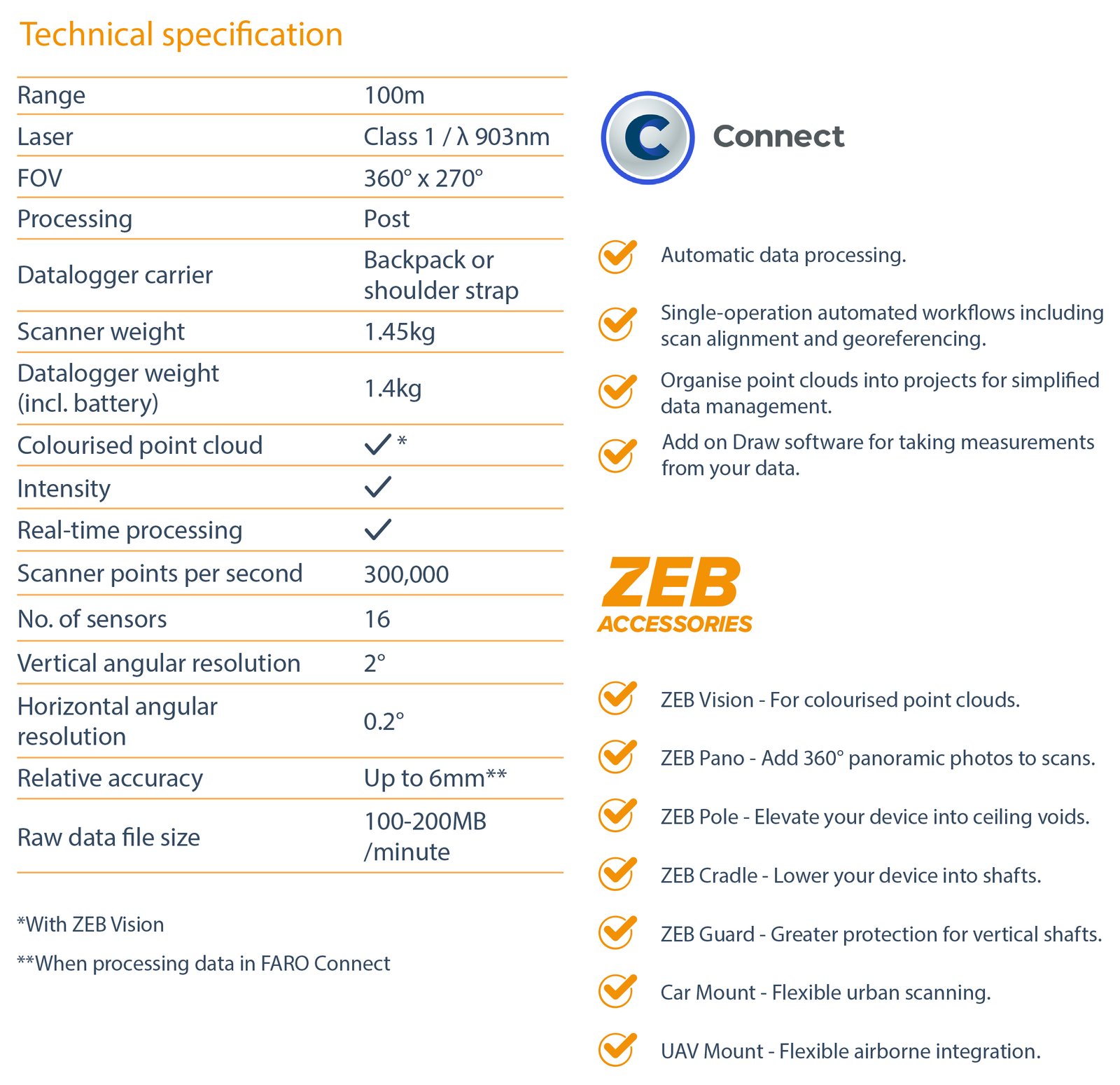
Features:
- 300,000 scan points per second
- 16 sensors
- Up to 6mm relative accuracy
- Up to 100-meter range
- Accessory options to enable users to capture data in a variety of ways
- Availability: In Stock
- Model: ZEB Horizon RT
-
Brand:

